Dalarö geodata
Dalarö (Stockholm) is a populated place; located in Sweden in Europe/Stockholm (GMT+2) time zone. With population of 1,849 people, there are 554 cities with bigger population in this country. Compared to other cities in Sweden, 55.6% of cities are located further ↓South; 90.1% of cities are located further ←West and 67.8% of cities have higher elevation than Dalarö. Note1


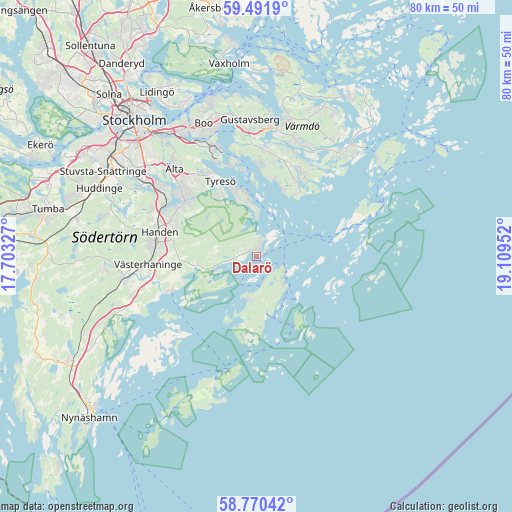
Dalarö GPS coordinates[2]
59° 7' 59.016" North, 18° 24' 23.004" East
| Map corner | latitude | longitude |
|---|---|---|
| Upper-left | 59.4919°, | 17.70327° |
| Center: | 59.13306°, | 18.40639° |
| Lower-right: | 58.77042°, | 19.10952° |
| Map W x H: | 80.2×80.2 km | = 49.8×49.8mi |
| max Lat: | 67.85572° ⇑44.4% North |
| Dalarö: | 59.13306° |
| min Lat: | ⇓55.6% South 55.34337° |
| min Long | Dalarö | max Long |
| 11.1712° | 18.40639° | 24.13676° |
| W 90.1%⇐ | ⇒9.9% E |
Elevation
Elevation of Dalarö is 27 m = 89 ft, and this is 55.6 m = 182 ft below average elevation for this country.
| Max E: |
663 m = 2175 ft | 67.8% |
| Avg. | 82.6 m = 271 ft | |
| Dalarö | 27 m = 89 ft | |
Min E: |
-1 m = -3 ft | 32.2% |
See also: Sweden elevation on elevation.city.
Geographical zone
Dalarö is located in North temperate zone (between Tropic of Cancer and the Arctic Circle). Distance of this North polar circle is 826.2 km =513.4 mi to North.| Distance of | km | miles | from Dalarö |
|---|---|---|---|
| North Pole | 3432.1 | 2132.6 | to North |
| Arctic Circle | 826.2 | 513.4 | to North |
| Tropic Cancer | 3969.1 | 2466.3 | to South |
| Equator | 6575 | 4085.5 | to South |


Nearby cities:
15 places around Dalarö: (largest is in red/bold)
• Bollmora
15.8 km =9.8 mi,  319°
319°
• Brevik
9.4 km =5.8 mi,  351°
351°
• Brunn
16.4 km =10.2 mi,  4°
4°
• Fisksätra
19.6 km =12.2 mi,  333°
333°
• Handen
15.8 km =9.8 mi,  284°
284°
• Haninge
15.4 km =9.6 mi, 284°
• Hemmesta
21.6 km =13.4 mi,  12°
12°
• Jordbro
16.6 km =10.3 mi, 276°
• Långvik
14 km =8.7 mi,  26°
26°
• Mörtnäs
20.7 km =12.9 mi, 5°
• Raksta
11.6 km =7.2 mi, 327°
• Saltsjöbaden
17.8 km =11.1 mi,  340°
340°
• Strömma
18.2 km =11.3 mi,  23°
23°
• Vidja
20.7 km =12.9 mi,  291°
291°
• Älta
19.5 km =12.1 mi, 319°
Sources, notices
• [Note1] Compared only with cities in Sweden existing in our database
• [Src1] Map data: © OpenStreetMap contributors (CC-BY-SA)
• [Src2] Other city data from geonames.org with taken over terms of usage.
• [Src3] Geographical zone / Annual Mean Temperature by Robert A. Rohde @ Wikipedia
