Överlida geodata
Överlida (Västra Götaland) is a populated place; located in Sweden in Europe/Stockholm (GMT+2) time zone. With population of 540 people, there are 1251 cities with bigger population in this country. Compared to other cities in Sweden, 74.3% of cities are located further ↑North; 82.7% of cities are located further →East and 79.6% of cities have lower elevation than Överlida. Note1


Överlida GPS coordinates[2]
57° 20' 58.452" North, 12° 53' 49.308" East
| Map corner | latitude | longitude |
|---|---|---|
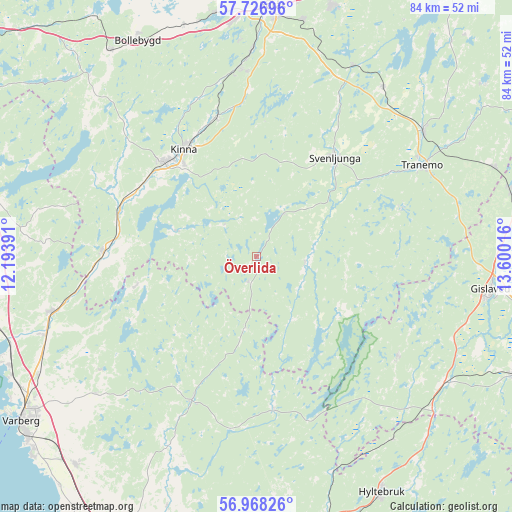
| Upper-left | 57.72696°, | 12.19391° |
| Center: | 57.34957°, | 12.89703° |
| Lower-right: | 56.96826°, | 13.60016° |
| Map W x H: | 84.4×84.4 km | = 52.4×52.4mi |
| max Lat: | 67.85572° ⇑74.3% North |
| Överlida: | 57.34957° |
| min Lat: | ⇓25.7% South 55.34337° |
| min Long | Överlida | max Long |
| 11.1712° | 12.89703° | 24.13676° |
| W 17.3%⇐ | ⇒82.7% E |
Elevation
Elevation of Överlida is 143 m = 469 ft, and this is 60.4 m = 198 ft above average elevation for this country.
| Max E: |
663 m = 2175 ft | 20.4% |
| Överlida | 143 m 469 ft | |
| Avg. | 82.6 m = 271 ft | |
Min E: |
-1 m = -3 ft | 79.6% |
See also: Sweden elevation on elevation.city.
Geographical zone
Överlida is located in North temperate zone (between Tropic of Cancer and the Arctic Circle). Distance of this North polar circle is 1024.5 km =636.6 mi to North.| Distance of | km | miles | from Överlida |
|---|---|---|---|
| North Pole | 3630.4 | 2255.8 | to North |
| Arctic Circle | 1024.5 | 636.6 | to North |
| Tropic Cancer | 3770.8 | 2343.1 | to South |
| Equator | 6376.7 | 3962.3 | to South |


Nearby cities:
15 places around Överlida: (largest is in red/bold)
• Björketorp
23.9 km =14.9 mi,  290°
290°
• Burseryd
28.6 km =17.8 mi,  125°
125°
• Fritsla
24 km =14.9 mi,  343°
343°
• Horred
25.2 km =15.7 mi,  271°
271°
• Hyssna
31.5 km =19.6 mi,  317°
317°
• Kinna
21.3 km =13.2 mi,  325°
325°
• Länghem
34.3 km =21.3 mi,  35°
35°
• Rydboholm
33.4 km =20.8 mi,  358°
358°
• Sexdrega
29.1 km =18.1 mi,  26°
26°
• Skällinge
31.8 km =19.8 mi,  234°
234°
• Svaneholm
30.1 km =18.7 mi,  350°
350°
• Svenljunga
20.7 km =12.9 mi, 38°
• Tranemo
30.9 km =19.2 mi,  61°
61°
• Ullared
26.4 km =16.4 mi,  204°
204°
• Viskafors
31.2 km =19.4 mi, 354°
Sources, notices
• [Note1] Compared only with cities in Sweden existing in our database
• [Src1] Map data: © OpenStreetMap contributors (CC-BY-SA)
• [Src2] Other city data from geonames.org with taken over terms of usage.
• [Src3] Geographical zone / Annual Mean Temperature by Robert A. Rohde @ Wikipedia
