Kinna geodata
Kinna (Västra Götaland) is a seat of a second-order administrative division; located in Sweden in Europe/Stockholm (GMT+2) time zone. With population of 15,019 people, there are 105 cities with bigger population in this country. Compared to other cities in Sweden, 71.3% of cities are located further ↑North; 86.4% of cities are located further →East and 57.9% of cities have lower elevation than Kinna. Note1


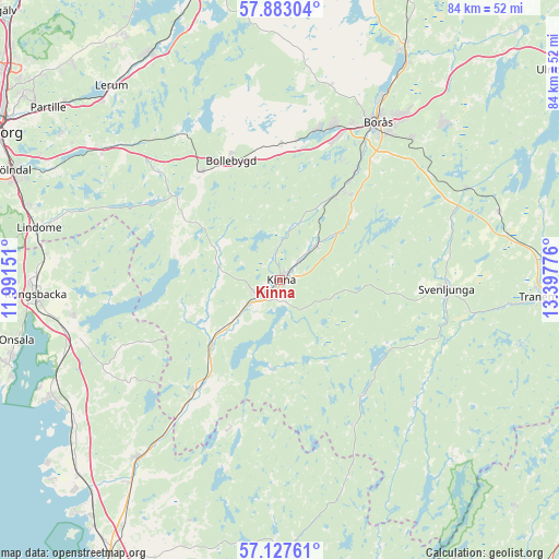
Kinna GPS coordinates[2]
57° 30' 26.208" North, 12° 41' 40.668" East
| Map corner | latitude | longitude |
|---|---|---|
| Upper-left | 57.88304°, | 11.99151° |
| Center: | 57.50728°, | 12.69463° |
| Lower-right: | 57.12761°, | 13.39776° |
| Map W x H: | 84×84 km | = 52.2×52.2mi |
| max Lat: | 67.85572° ⇑71.3% North |
| Kinna: | 57.50728° |
| min Lat: | ⇓28.7% South 55.34337° |
| min Long | Kinna | max Long |
| 11.1712° | 12.69463° | 24.13676° |
| W 13.6%⇐ | ⇒86.4% E |
Elevation
Elevation of Kinna is 65 m = 213 ft, and this is 17.6 m = 58 ft below average elevation for this country.
| Max E: |
663 m = 2175 ft | 42.1% |
| Avg. | 82.6 m = 271 ft | |
| Kinna | 65 m = 213 ft | |
Min E: |
-1 m = -3 ft | 57.9% |
See also: Sweden elevation on elevation.city.
Geographical zone
Kinna is located in North temperate zone (between Tropic of Cancer and the Arctic Circle). Distance of this North polar circle is 1007 km =625.7 mi to North.| Distance of | km | miles | from Kinna |
|---|---|---|---|
| North Pole | 3612.9 | 2245 | to North |
| Arctic Circle | 1007 | 625.7 | to North |
| Tropic Cancer | 3788.3 | 2353.9 | to South |
| Equator | 6394.2 | 3973.2 | to South |


Nearby cities:
15 places around Kinna: (largest is in red/bold)
• Björketorp
13.5 km =8.4 mi,  228°
228°
• Bollebygd
19.4 km =12.1 mi,  337°
337°
• Fritsla
7.7 km =4.8 mi,  44°
44°
• Horred
21.4 km =13.3 mi,  217°
217°
• Hyssna
10.9 km =6.8 mi,  300°
300°
• Olsfors
20.4 km =12.7 mi,  0°
0°
• Rydboholm
19.5 km =12.1 mi, 35°
• Rävlanda
20 km =12.4 mi,  324°
324°
• Sandared
23.3 km =14.5 mi,  14°
14°
• Sjömarken
24.6 km =15.3 mi,  19°
19°
• Svaneholm
14.2 km =8.8 mi,  30°
30°
• Svenljunga
24.9 km =15.5 mi,  93°
93°
• Sätila
16 km =9.9 mi,  283°
283°
• Viskafors
16.4 km =10.2 mi, 34°
• Överlida
21.3 km =13.2 mi,  145°
145°
Sources, notices
• [Note1] Compared only with cities in Sweden existing in our database
• [Src1] Map data: © OpenStreetMap contributors (CC-BY-SA)
• [Src2] Other city data from geonames.org with taken over terms of usage.
• [Src3] Geographical zone / Annual Mean Temperature by Robert A. Rohde @ Wikipedia
