Skruv geodata
Skruv (Kronoberg) is a populated place; located in Sweden in Europe/Stockholm (GMT+2) time zone. With population of 586 people, there are 1191 cities with bigger population in this country. Compared to other cities in Sweden, 81.5% of cities are located further ↑North; 54.1% of cities are located further ←West and 78.9% of cities have lower elevation than Skruv. Note1


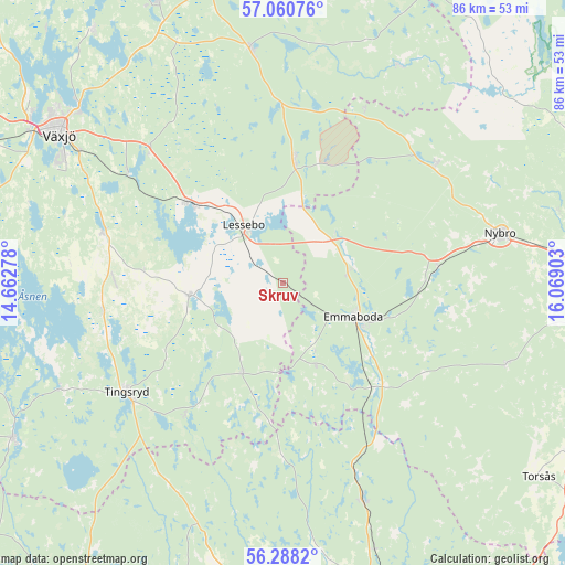
Skruv GPS coordinates[2]
56° 40' 35.256" North, 15° 21' 57.24" East
| Map corner | latitude | longitude |
|---|---|---|
| Upper-left | 57.06076°, | 14.66278° |
| Center: | 56.67646°, | 15.3659° |
| Lower-right: | 56.2882°, | 16.06903° |
| Map W x H: | 85.9×85.9 km | = 53.4×53.4mi |
| max Lat: | 67.85572° ⇑81.5% North |
| Skruv: | 56.67646° |
| min Lat: | ⇓18.5% South 55.34337° |
| min Long | Skruv | max Long |
| 11.1712° | 15.3659° | 24.13676° |
| W 54.1%⇐ | ⇒45.9% E |
Elevation
Elevation of Skruv is 139 m = 456 ft, and this is 56.4 m = 185 ft above average elevation for this country.
| Max E: |
663 m = 2175 ft | 21.1% |
| Skruv | 139 m 456 ft | |
| Avg. | 82.6 m = 271 ft | |
Min E: |
-1 m = -3 ft | 78.9% |
See also: Sweden elevation on elevation.city.
Geographical zone
Skruv is located in North temperate zone (between Tropic of Cancer and the Arctic Circle). Distance of this North polar circle is 1099.3 km =683.1 mi to North.| Distance of | km | miles | from Skruv |
|---|---|---|---|
| North Pole | 3705.2 | 2302.3 | to North |
| Arctic Circle | 1099.3 | 683.1 | to North |
| Tropic Cancer | 3695.9 | 2296.5 | to South |
| Equator | 6301.8 | 3915.8 | to South |


Nearby cities:
15 places around Skruv: (largest is in red/bold)
• Alstermo
37.3 km =23.2 mi,  28°
28°
• Emmaboda
11.5 km =7.1 mi,  115°
115°
• Hovmantorp
18.4 km =11.4 mi,  311°
311°
• Ingelstad
28.6 km =17.8 mi,  286°
286°
• Kosta
18.6 km =11.6 mi,  5°
5°
• Lenhovda
36.3 km =22.6 mi,  352°
352°
• Lessebo
10.2 km =6.3 mi,  324°
324°
• Nybro
33.9 km =21.1 mi,  77°
77°
• Orrefors
29.5 km =18.3 mi,  51°
51°
• Påryd
35.8 km =22.2 mi,  109°
109°
• Tingsryd
29.1 km =18.1 mi,  234°
234°
• Urshult
39 km =24.2 mi,  245°
245°
• Vissefjärda
20.7 km =12.9 mi,  140°
140°
• Väckelsång
27.9 km =17.3 mi,  260°
260°
• Åryd
28.9 km =18 mi, 305°
Sources, notices
• [Note1] Compared only with cities in Sweden existing in our database
• [Src1] Map data: © OpenStreetMap contributors (CC-BY-SA)
• [Src2] Other city data from geonames.org with taken over terms of usage.
• [Src3] Geographical zone / Annual Mean Temperature by Robert A. Rohde @ Wikipedia
