Nora geodata
Nora (Örebro) is a seat of a second-order administrative division; located in Sweden in Europe/Stockholm (GMT+2) time zone. With population of 6,597 people, there are 215 cities with bigger population in this country. Compared to other cities in Sweden, 66.7% of cities are located further ↓South; 50.1% of cities are located further →East and 71.6% of cities have lower elevation than Nora. Note1


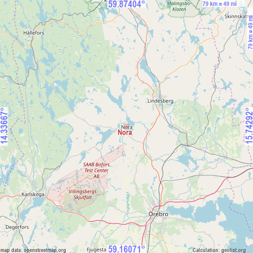
Nora GPS coordinates[2]
59° 31' 9.336" North, 15° 2' 23.244" East
| Map corner | latitude | longitude |
|---|---|---|
| Upper-left | 59.87404°, | 14.33667° |
| Center: | 59.51926°, | 15.03979° |
| Lower-right: | 59.16071°, | 15.74292° |
| Map W x H: | 79.3×79.3 km | = 49.3×49.3mi |
| max Lat: | 67.85572° ⇑33.3% North |
| Nora: | 59.51926° |
| min Lat: | ⇓66.7% South 55.34337° |
| min Long | Nora | max Long |
| 11.1712° | 15.03979° | 24.13676° |
| W 49.9%⇐ | ⇒50.1% E |
Elevation
Elevation of Nora is 104 m = 341 ft, and this is 21.4 m = 70 ft above average elevation for this country.
| Max E: |
663 m = 2175 ft | 28.4% |
| Nora | 104 m 341 ft | |
| Avg. | 82.6 m = 271 ft | |
Min E: |
-1 m = -3 ft | 71.6% |
See also: Sweden elevation on elevation.city.
Geographical zone
Nora is located in North temperate zone (between Tropic of Cancer and the Arctic Circle). Distance of this North polar circle is 783.3 km =486.7 mi to North.| Distance of | km | miles | from Nora |
|---|---|---|---|
| North Pole | 3389.1 | 2105.9 | to North |
| Arctic Circle | 783.3 | 486.7 | to North |
| Tropic Cancer | 4012 | 2492.9 | to South |
| Equator | 6617.9 | 4112.2 | to South |


Nearby cities:
15 places around Nora: (largest is in red/bold)
• Ekeby-Almby
33.2 km =20.6 mi,  150°
150°
• Fellingsbro
32.1 km =19.9 mi,  107°
107°
• Frövi
19.4 km =12.1 mi, 107°
• Garphyttan
24.5 km =15.2 mi,  192°
192°
• Glanshammar
30.4 km =18.9 mi,  137°
137°
• Gyttorp
4.4 km =2.7 mi,  249°
249°
• Hovsta
21.3 km =13.2 mi, 152°
• Latorpsbruk
27.6 km =17.1 mi, 186°
• Lindesberg
13.4 km =8.3 mi,  53°
53°
• Rinkaby
31.2 km =19.4 mi,  100°
100°
• Storå
22.3 km =13.9 mi,  13°
13°
• Vedevåg
14.3 km =8.9 mi,  86°
86°
• Vintrosa
30.4 km =18.9 mi, 189°
• Ölmbrotorp
18.2 km =11.3 mi, 140°
• Örebro
28.8 km =17.9 mi,  160°
160°
Sources, notices
• [Note1] Compared only with cities in Sweden existing in our database
• [Src1] Map data: © OpenStreetMap contributors (CC-BY-SA)
• [Src2] Other city data from geonames.org with taken over terms of usage.
• [Src3] Geographical zone / Annual Mean Temperature by Robert A. Rohde @ Wikipedia
