Gyttorp geodata
Gyttorp (Örebro) is a populated place; located in Sweden in Europe/Stockholm (GMT+2) time zone. With population of 671 people, there are 1097 cities with bigger population in this country. Compared to other cities in Sweden, 66.3% of cities are located further ↓South; 51.6% of cities are located further →East and 75.7% of cities have lower elevation than Gyttorp. Note1
Administrative division(s):
- Level 1: Örebro
- Level 2: Nora Kommun
- Level 3: Nora bergsförs.
- Level 4: Nora socken


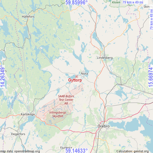
Gyttorp GPS coordinates[2]
59° 30' 18.108" North, 14° 57' 59.796" East
| Map corner | latitude | longitude |
|---|---|---|
| Upper-left | 59.85996°, | 14.26349° |
| Center: | 59.50503°, | 14.96661° |
| Lower-right: | 59.14633°, | 15.66974° |
| Map W x H: | 79.3×79.3 km | = 49.3×49.3mi |
| max Lat: | 67.85572° ⇑33.7% North |
| Gyttorp: | 59.50503° |
| min Lat: | ⇓66.3% South 55.34337° |
| min Long | Gyttorp | max Long |
| 11.1712° | 14.96661° | 24.13676° |
| W 48.4%⇐ | ⇒51.6% E |
Elevation
Elevation of Gyttorp is 123 m = 404 ft, and this is 40.4 m = 133 ft above average elevation for this country.
| Max E: |
663 m = 2175 ft | 24.3% |
| Gyttorp | 123 m 404 ft | |
| Avg. | 82.6 m = 271 ft | |
Min E: |
-1 m = -3 ft | 75.7% |
See also: Sweden elevation on elevation.city.
Geographical zone
Gyttorp is located in North temperate zone (between Tropic of Cancer and the Arctic Circle). Distance of this North polar circle is 784.8 km =487.7 mi to North.| Distance of | km | miles | from Gyttorp |
|---|---|---|---|
| North Pole | 3390.7 | 2106.9 | to North |
| Arctic Circle | 784.8 | 487.7 | to North |
| Tropic Cancer | 4010.4 | 2491.9 | to South |
| Equator | 6616.3 | 4111.2 | to South |


Nearby cities:
15 places around Gyttorp: (largest is in red/bold)
• Ekeby-Almby
34.1 km =21.2 mi,  142°
142°
• Frövi
23 km =14.3 mi,  100°
100°
• Garphyttan
22.3 km =13.9 mi,  182°
182°
• Glanshammar
32.2 km =20 mi,  130°
130°
• Grythyttan
33 km =20.5 mi,  312°
312°
• Hovsta
22.3 km =13.9 mi, 140°
• Karlskoga
31.9 km =19.8 mi,  231°
231°
• Latorpsbruk
25.9 km =16.1 mi, 177°
• Lindesberg
17.7 km =11 mi,  56°
56°
• Nora
4.4 km =2.7 mi,  69°
69°
• Storå
25 km =15.5 mi,  21°
21°
• Vedevåg
18.5 km =11.5 mi,  82°
82°
• Vintrosa
28.4 km =17.6 mi, 181°
• Ölmbrotorp
20 km =12.4 mi, 128°
• Örebro
29 km =18 mi,  152°
152°
Sources, notices
• [Note1] Compared only with cities in Sweden existing in our database
• [Src1] Map data: © OpenStreetMap contributors (CC-BY-SA)
• [Src2] Other city data from geonames.org with taken over terms of usage.
• [Src3] Geographical zone / Annual Mean Temperature by Robert A. Rohde @ Wikipedia
