Storå geodata
Storå (Örebro) is a populated place; located in Sweden in Europe/Stockholm (GMT+2) time zone. With population of 1,967 people, there are 527 cities with bigger population in this country. Compared to other cities in Sweden, 70.1% of cities are located further ↓South; 51.4% of cities are located further ←West and 59.9% of cities have lower elevation than Storå. Note1
Administrative division(s):
- Level 1: Örebro
- Level 2: Lindesbergs Kommun
- Level 3: Lindesberg
- Level 4: Linde socken


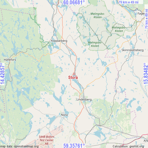
Storå GPS coordinates[2]
59° 42' 50.724" North, 15° 7' 54.084" East
| Map corner | latitude | longitude |
|---|---|---|
| Upper-left | 60.06681°, | 14.42857° |
| Center: | 59.71409°, | 15.13169° |
| Lower-right: | 59.35761°, | 15.83482° |
| Map W x H: | 78.9×78.9 km | = 49×49mi |
| max Lat: | 67.85572° ⇑29.9% North |
| Storå: | 59.71409° |
| min Lat: | ⇓70.1% South 55.34337° |
| min Long | Storå | max Long |
| 11.1712° | 15.13169° | 24.13676° |
| W 51.4%⇐ | ⇒48.6% E |
Elevation
Elevation of Storå is 71 m = 233 ft, and this is 11.6 m = 38 ft below average elevation for this country.
| Max E: |
663 m = 2175 ft | 40.1% |
| Avg. | 82.6 m = 271 ft | |
| Storå | 71 m = 233 ft | |
Min E: |
-1 m = -3 ft | 59.9% |
See also: Sweden elevation on elevation.city.
Geographical zone
Storå is located in North temperate zone (between Tropic of Cancer and the Arctic Circle). Distance of this North polar circle is 761.6 km =473.2 mi to North.| Distance of | km | miles | from Storå |
|---|---|---|---|
| North Pole | 3367.5 | 2092.5 | to North |
| Arctic Circle | 761.6 | 473.2 | to North |
| Tropic Cancer | 4033.7 | 2506.4 | to South |
| Equator | 6639.6 | 4125.7 | to South |


Nearby cities:
15 places around Storå: (largest is in red/bold)
• Fellingsbro
40.3 km =25 mi,  140°
140°
• Frövi
30.5 km =19 mi,  154°
154°
• Grythyttan
33.5 km =20.8 mi,  268°
268°
• Grängesberg
40.7 km =25.3 mi,  350°
350°
• Gyttorp
25 km =15.5 mi,  201°
201°
• Hovsta
40.8 km =25.4 mi,  173°
173°
• Hällefors
35 km =21.7 mi,  282°
282°
• Kolsva
41.4 km =25.7 mi,  107°
107°
• Kopparberg
19.6 km =12.2 mi,  336°
336°
• Lindesberg
14.7 km =9.1 mi,  157°
157°
• Nora
22.3 km =13.9 mi,  193°
193°
• Rinkaby
37.5 km =23.3 mi, 137°
• Skinnskatteberg
34 km =21.1 mi,  67°
67°
• Vedevåg
22.7 km =14.1 mi, 156°
• Ölmbrotorp
36.3 km =22.6 mi, 170°
Sources, notices
• [Note1] Compared only with cities in Sweden existing in our database
• [Src1] Map data: © OpenStreetMap contributors (CC-BY-SA)
• [Src2] Other city data from geonames.org with taken over terms of usage.
• [Src3] Geographical zone / Annual Mean Temperature by Robert A. Rohde @ Wikipedia
