Hällekis geodata
Hällekis (Västra Götaland) is a populated place; located in Sweden in Europe/Stockholm (GMT+2) time zone. With population of 683 people, there are 1086 cities with bigger population in this country. Compared to other cities in Sweden, 50.7% of cities are located further ↑North; 72.3% of cities are located further →East and 60.4% of cities have lower elevation than Hällekis. Note1


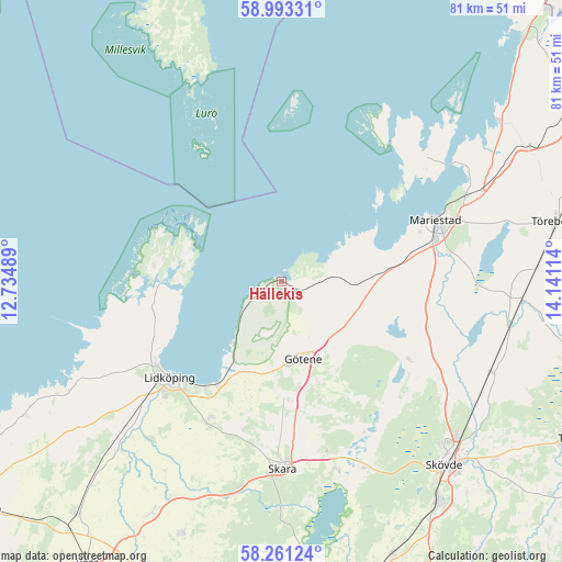
Hällekis GPS coordinates[2]
58° 37' 45.084" North, 13° 26' 16.836" East
| Map corner | latitude | longitude |
|---|---|---|
| Upper-left | 58.99331°, | 12.73489° |
| Center: | 58.62919°, | 13.43801° |
| Lower-right: | 58.26124°, | 14.14114° |
| Map W x H: | 81.4×81.4 km | = 50.6×50.6mi |
| max Lat: | 67.85572° ⇑50.7% North |
| Hällekis: | 58.62919° |
| min Lat: | ⇓49.3% South 55.34337° |
| min Long | Hällekis | max Long |
| 11.1712° | 13.43801° | 24.13676° |
| W 27.7%⇐ | ⇒72.3% E |
Elevation
Elevation of Hällekis is 72 m = 236 ft, and this is 10.6 m = 35 ft below average elevation for this country.
| Max E: |
663 m = 2175 ft | 39.6% |
| Avg. | 82.6 m = 271 ft | |
| Hällekis | 72 m = 236 ft | |
Min E: |
-1 m = -3 ft | 60.4% |
See also: Sweden elevation on elevation.city.
Geographical zone
Hällekis is located in North temperate zone (between Tropic of Cancer and the Arctic Circle). Distance of this North polar circle is 882.2 km =548.2 mi to North.| Distance of | km | miles | from Hällekis |
|---|---|---|---|
| North Pole | 3488.1 | 2167.4 | to North |
| Arctic Circle | 882.2 | 548.2 | to North |
| Tropic Cancer | 3913 | 2431.4 | to South |
| Equator | 6519 | 4050.7 | to South |


Nearby cities:
15 places around Hällekis: (largest is in red/bold)
• Axvall
28.3 km =17.6 mi,  164°
164°
• Filsbäck
18.9 km =11.7 mi,  215°
215°
• Götene
11.7 km =7.3 mi, 163°
• Källby
15.3 km =9.5 mi,  210°
210°
• Lerdala
23.1 km =14.4 mi,  136°
136°
• Lidköping
21.3 km =13.2 mi,  229°
229°
• Lugnås
15.3 km =9.5 mi,  84°
84°
• Lundsbrunn
17.5 km =10.9 mi,  178°
178°
• Mariestad
24 km =14.9 mi,  68°
68°
• Skara
27 km =16.8 mi, 179°
• Stöpen
30 km =18.6 mi,  124°
124°
• Timmersdala
21 km =13 mi, 120°
• Ullervad
25.1 km =15.6 mi, 80°
• Varnhem
30 km =18.6 mi, 155°
• Vinninga
22.3 km =13.9 mi, 206°
Sources, notices
• [Note1] Compared only with cities in Sweden existing in our database
• [Src1] Map data: © OpenStreetMap contributors (CC-BY-SA)
• [Src2] Other city data from geonames.org with taken over terms of usage.
• [Src3] Geographical zone / Annual Mean Temperature by Robert A. Rohde @ Wikipedia
