Lugnås geodata
Lugnås (Västra Götaland) is a populated place; located in Sweden in Europe/Stockholm (GMT+2) time zone. With population of 641 people, there are 1132 cities with bigger population in this country. Compared to other cities in Sweden, 50.5% of cities are located further ↑North; 68% of cities are located further →East and 56.2% of cities have lower elevation than Lugnås. Note1
Administrative division(s):
- Level 1: Västra Götaland
- Level 2: Mariestads Kommun
- Level 3: Lugnås
- Level 4: Björsäter socken


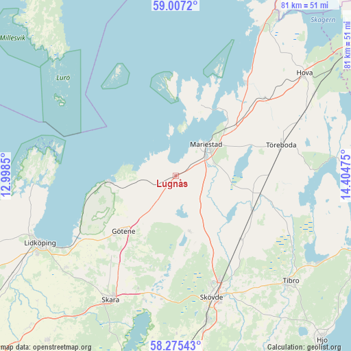
Lugnås GPS coordinates[2]
58° 38' 35.628" North, 13° 42' 5.832" East
| Map corner | latitude | longitude |
|---|---|---|
| Upper-left | 59.0072°, | 12.9985° |
| Center: | 58.64323°, | 13.70162° |
| Lower-right: | 58.27543°, | 14.40475° |
| Map W x H: | 81.4×81.4 km | = 50.6×50.6mi |
| max Lat: | 67.85572° ⇑50.5% North |
| Lugnås: | 58.64323° |
| min Lat: | ⇓49.5% South 55.34337° |
| min Long | Lugnås | max Long |
| 11.1712° | 13.70162° | 24.13676° |
| W 32%⇐ | ⇒68% E |
Elevation
Elevation of Lugnås is 61 m = 200 ft, and this is 21.6 m = 71 ft below average elevation for this country.
| Max E: |
663 m = 2175 ft | 43.8% |
| Avg. | 82.6 m = 271 ft | |
| Lugnås | 61 m = 200 ft | |
Min E: |
-1 m = -3 ft | 56.2% |
See also: Sweden elevation on elevation.city.
Geographical zone
Lugnås is located in North temperate zone (between Tropic of Cancer and the Arctic Circle). Distance of this North polar circle is 880.7 km =547.2 mi to North.| Distance of | km | miles | from Lugnås |
|---|---|---|---|
| North Pole | 3486.5 | 2166.4 | to North |
| Arctic Circle | 880.7 | 547.2 | to North |
| Tropic Cancer | 3914.6 | 2432.4 | to South |
| Equator | 6520.5 | 4051.6 | to South |


Nearby cities:
15 places around Lugnås: (largest is in red/bold)
• Götene
17.5 km =10.9 mi,  223°
223°
• Hällekis
15.3 km =9.5 mi,  264°
264°
• Källby
27.3 km =17 mi,  237°
237°
• Lerdala
18.3 km =11.4 mi,  177°
177°
• Lundsbrunn
24.1 km =15 mi, 217°
• Mariestad
10.2 km =6.3 mi,  43°
43°
• Moholm
20 km =12.4 mi,  101°
101°
• Skövde
29.2 km =18.1 mi,  163°
163°
• Stöpen
20.7 km =12.9 mi,  152°
152°
• Tidan
19.2 km =11.9 mi,  113°
113°
• Timmersdala
12.5 km =7.8 mi,  167°
167°
• Töreboda
25.5 km =15.8 mi,  73°
73°
• Ullervad
9.9 km =6.2 mi, 74°
• Varnhem
29.1 km =18.1 mi,  185°
185°
• Väring
21.8 km =13.5 mi,  134°
134°
Sources, notices
• [Note1] Compared only with cities in Sweden existing in our database
• [Src1] Map data: © OpenStreetMap contributors (CC-BY-SA)
• [Src2] Other city data from geonames.org with taken over terms of usage.
• [Src3] Geographical zone / Annual Mean Temperature by Robert A. Rohde @ Wikipedia
