Kårsta geodata
Kårsta (Stockholm) is a populated place; located in Sweden in Europe/Stockholm (GMT+2) time zone. With population of 502 people, there are 1310 cities with bigger population in this country. Compared to other cities in Sweden, 69.3% of cities are located further ↓South; 88.7% of cities are located further ←West and 60.3% of cities have higher elevation than Kårsta. Note1
Administrative division(s):
- Level 1: Stockholm
- Level 2: Vallentuna Kommun
- Level 3: Össeby
- Level 4: Kårsta socken


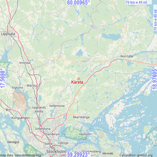
Kårsta GPS coordinates[2]
59° 39' 22.752" North, 18° 16' 22.512" East
| Map corner | latitude | longitude |
|---|---|---|
| Upper-left | 60.00965°, | 17.5698° |
| Center: | 59.65632°, | 18.27292° |
| Lower-right: | 59.29923°, | 18.97605° |
| Map W x H: | 79×79 km | = 49.1×49.1mi |
| max Lat: | 67.85572° ⇑30.7% North |
| Kårsta: | 59.65632° |
| min Lat: | ⇓69.3% South 55.34337° |
| min Long | Kårsta | max Long |
| 11.1712° | 18.27292° | 24.13676° |
| W 88.7%⇐ | ⇒11.3% E |
Elevation
Elevation of Kårsta is 35 m = 115 ft, and this is 47.6 m = 156 ft below average elevation for this country.
| Max E: |
663 m = 2175 ft | 60.3% |
| Avg. | 82.6 m = 271 ft | |
| Kårsta | 35 m = 115 ft | |
Min E: |
-1 m = -3 ft | 39.7% |
See also: Sweden elevation on elevation.city.
Geographical zone
Kårsta is located in North temperate zone (between Tropic of Cancer and the Arctic Circle). Distance of this North polar circle is 768 km =477.2 mi to North.| Distance of | km | miles | from Kårsta |
|---|---|---|---|
| North Pole | 3373.9 | 2096.4 | to North |
| Arctic Circle | 768 | 477.2 | to North |
| Tropic Cancer | 4027.2 | 2502.4 | to South |
| Equator | 6633.2 | 4121.7 | to South |


Nearby cities:
15 places around Kårsta: (largest is in red/bold)
• Bergshamra
20.1 km =12.5 mi,  96°
96°
• Karby
11 km =6.8 mi,  195°
195°
• Lindholmen
12.7 km =7.9 mi,  230°
230°
• Märsta
23.8 km =14.8 mi,  260°
260°
• Norrtälje
26.7 km =16.6 mi,  64°
64°
• Nykvarn
16 km =9.9 mi,  5°
5°
• Resarö
25.5 km =15.8 mi,  172°
172°
• Rimbo
11.7 km =7.3 mi,  26°
26°
• Rosersberg
23.4 km =14.5 mi,  249°
249°
• Rydbo
22.2 km =13.8 mi,  192°
192°
• Steninge
27 km =16.8 mi, 257°
• Täby
26.3 km =16.3 mi,  205°
205°
• Upplands Väsby
25.5 km =15.8 mi, 233°
• Vallentuna
17.5 km =10.9 mi,  219°
219°
• Åkersberga
19.7 km =12.2 mi,  175°
175°
Sources, notices
• [Note1] Compared only with cities in Sweden existing in our database
• [Src1] Map data: © OpenStreetMap contributors (CC-BY-SA)
• [Src2] Other city data from geonames.org with taken over terms of usage.
• [Src3] Geographical zone / Annual Mean Temperature by Robert A. Rohde @ Wikipedia
