Landsbro geodata
Landsbro (Jönköping) is a populated place; located in Sweden in Europe/Stockholm (GMT+2) time zone. With population of 1,438 people, there are 677 cities with bigger population in this country. Compared to other cities in Sweden, 73.7% of cities are located further ↑North; 52.5% of cities are located further →East and 90.5% of cities have lower elevation than Landsbro. Note1


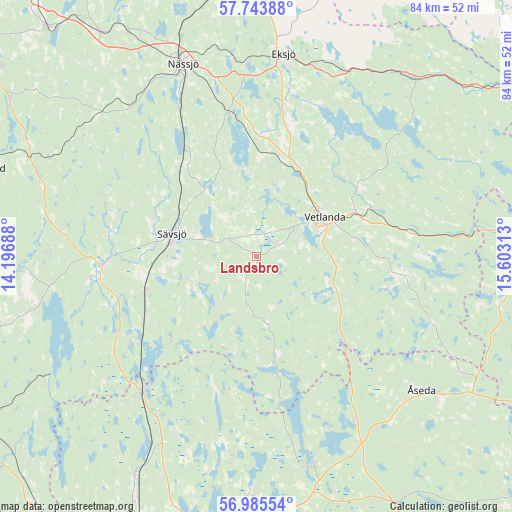
Landsbro GPS coordinates[2]
57° 22' 0.012" North, 14° 54' 0" East
| Map corner | latitude | longitude |
|---|---|---|
| Upper-left | 57.74388°, | 14.19688° |
| Center: | 57.36667°, | 14.9° |
| Lower-right: | 56.98554°, | 15.60313° |
| Map W x H: | 84.3×84.3 km | = 52.4×52.4mi |
| max Lat: | 67.85572° ⇑73.7% North |
| Landsbro: | 57.36667° |
| min Lat: | ⇓26.3% South 55.34337° |
| min Long | Landsbro | max Long |
| 11.1712° | 14.9° | 24.13676° |
| W 47.5%⇐ | ⇒52.5% E |
Elevation
Elevation of Landsbro is 205 m = 673 ft, and this is 122.4 m = 402 ft above average elevation for this country.
| Max E: |
663 m = 2175 ft | 9.5% |
| Landsbro | 205 m 673 ft | |
| Avg. | 82.6 m = 271 ft | |
Min E: |
-1 m = -3 ft | 90.5% |
See also: Sweden elevation on elevation.city.
Geographical zone
Landsbro is located in North temperate zone (between Tropic of Cancer and the Arctic Circle). Distance of this North polar circle is 1022.6 km =635.4 mi to North.| Distance of | km | miles | from Landsbro |
|---|---|---|---|
| North Pole | 3628.5 | 2254.6 | to North |
| Arctic Circle | 1022.6 | 635.4 | to North |
| Tropic Cancer | 3772.7 | 2344.2 | to South |
| Equator | 6378.6 | 3963.5 | to South |


Nearby cities:
15 places around Landsbro: (largest is in red/bold)
• Bodafors
19.1 km =11.9 mi,  321°
321°
• Burseryd
7 km =4.3 mi,  270°
270°
• Ekenässjön
15.7 km =9.8 mi,  27°
27°
• Eksjö
33.6 km =20.9 mi,  7°
7°
• Holsbybrunn
19.4 km =12.1 mi,  67°
67°
• Hällaryd
19.5 km =12.1 mi,  55°
55°
• Korsberga
15.3 km =9.5 mi,  117°
117°
• Lammhult
29.3 km =18.2 mi,  220°
220°
• Myresjö
4.3 km =2.7 mi, 61°
• Rörvik
24.1 km =15 mi,  233°
233°
• Skruv
28.9 km =18 mi,  146°
146°
• Stockaryd
19.2 km =11.9 mi,  253°
253°
• Sävsjö
14.8 km =9.2 mi,  285°
285°
• Vetlanda
12.7 km =7.9 mi, 56°
• Vrigstad
26.1 km =16.2 mi, 265°
Sources, notices
• [Note1] Compared only with cities in Sweden existing in our database
• [Src1] Map data: © OpenStreetMap contributors (CC-BY-SA)
• [Src2] Other city data from geonames.org with taken over terms of usage.
• [Src3] Geographical zone / Annual Mean Temperature by Robert A. Rohde @ Wikipedia
