Kimstad geodata
Kimstad (Östergötland) is a populated place; located in Sweden in Europe/Stockholm (GMT+2) time zone. With population of 1,469 people, there are 666 cities with bigger population in this country. Compared to other cities in Sweden, 51.7% of cities are located further ↑North; 61.4% of cities are located further ←West and 53.8% of cities have higher elevation than Kimstad. Note1
Administrative division(s):
- Level 1: Östergötland
- Level 2: Norrköpings Kommun
- Level 3: Kimstad
- Level 4: Kimstad socken


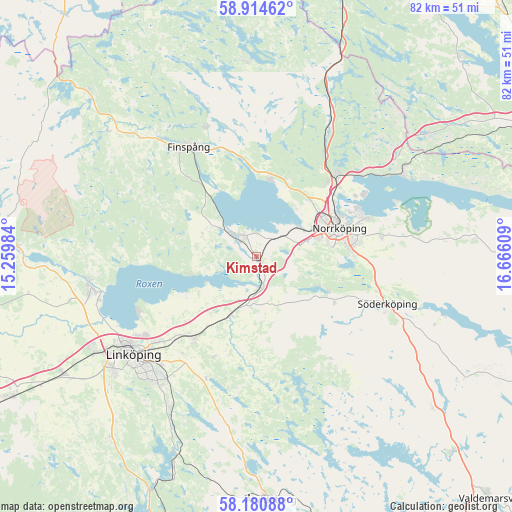
Kimstad GPS coordinates[2]
58° 32' 58.812" North, 15° 57' 46.656" East
| Map corner | latitude | longitude |
|---|---|---|
| Upper-left | 58.91462°, | 15.25984° |
| Center: | 58.54967°, | 15.96296° |
| Lower-right: | 58.18088°, | 16.66609° |
| Map W x H: | 81.6×81.6 km | = 50.7×50.7mi |
| max Lat: | 67.85572° ⇑51.7% North |
| Kimstad: | 58.54967° |
| min Lat: | ⇓48.3% South 55.34337° |
| min Long | Kimstad | max Long |
| 11.1712° | 15.96296° | 24.13676° |
| W 61.4%⇐ | ⇒38.6% E |
Elevation
Elevation of Kimstad is 44 m = 144 ft, and this is 38.6 m = 127 ft below average elevation for this country.
| Max E: |
663 m = 2175 ft | 53.8% |
| Avg. | 82.6 m = 271 ft | |
| Kimstad | 44 m = 144 ft | |
Min E: |
-1 m = -3 ft | 46.2% |
See also: Sweden elevation on elevation.city.
Geographical zone
Kimstad is located in North temperate zone (between Tropic of Cancer and the Arctic Circle). Distance of this North polar circle is 891.1 km =553.7 mi to North.| Distance of | km | miles | from Kimstad |
|---|---|---|---|
| North Pole | 3496.9 | 2172.9 | to North |
| Arctic Circle | 891.1 | 553.7 | to North |
| Tropic Cancer | 3904.2 | 2426 | to South |
| Equator | 6510.1 | 4045.2 | to South |


Nearby cities:
15 places around Kimstad: (largest is in red/bold)
• Askeby
17.1 km =10.6 mi,  202°
202°
• Ekängen
21.3 km =13.2 mi,  244°
244°
• Finspång
20.7 km =12.9 mi,  326°
326°
• Jursla
18.2 km =11.3 mi,  44°
44°
• Lindö
18.2 km =11.3 mi,  65°
65°
• Linghem
16.6 km =10.3 mi,  218°
218°
• Lotorp
21.8 km =13.5 mi,  339°
339°
• Norrköping
13.7 km =8.5 mi, 68°
• Norsholm
5 km =3.1 mi,  173°
173°
• Ruda
14.7 km =9.1 mi,  309°
309°
• Skärblacka
4.1 km =2.5 mi,  297°
297°
• Svärtinge
12.3 km =7.6 mi,  17°
17°
• Tallboda
21.4 km =13.3 mi,  229°
229°
• Åby
18.2 km =11.3 mi, 44°
• Öbonäs
13.2 km =8.2 mi,  93°
93°
Sources, notices
• [Note1] Compared only with cities in Sweden existing in our database
• [Src1] Map data: © OpenStreetMap contributors (CC-BY-SA)
• [Src2] Other city data from geonames.org with taken over terms of usage.
• [Src3] Geographical zone / Annual Mean Temperature by Robert A. Rohde @ Wikipedia
