Finspång geodata
Finspång (Östergötland) is a seat of a second-order administrative division; located in Sweden in Europe/Stockholm (GMT+2) time zone. With population of 12,807 people, there are 122 cities with bigger population in this country. Compared to other cities in Sweden, 50.5% of cities are located further ↓South; 59.1% of cities are located further ←West and 52.4% of cities have higher elevation than Finspång. Note1


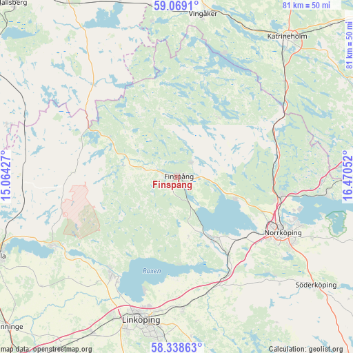
Finspång GPS coordinates[2]
58° 42' 20.808" North, 15° 46' 2.604" East
| Map corner | latitude | longitude |
|---|---|---|
| Upper-left | 59.0691°, | 15.06427° |
| Center: | 58.70578°, | 15.76739° |
| Lower-right: | 58.33863°, | 16.47052° |
| Map W x H: | 81.2×81.2 km | = 50.5×50.5mi |
| max Lat: | 67.85572° ⇑49.5% North |
| Finspång: | 58.70578° |
| min Lat: | ⇓50.5% South 55.34337° |
| min Long | Finspång | max Long |
| 11.1712° | 15.76739° | 24.13676° |
| W 59.1%⇐ | ⇒40.9% E |
Elevation
Elevation of Finspång is 46 m = 151 ft, and this is 36.6 m = 120 ft below average elevation for this country.
| Max E: |
663 m = 2175 ft | 52.4% |
| Avg. | 82.6 m = 271 ft | |
| Finspång | 46 m = 151 ft | |
Min E: |
-1 m = -3 ft | 47.6% |
See also: Sweden elevation on elevation.city.
Geographical zone
Finspång is located in North temperate zone (between Tropic of Cancer and the Arctic Circle). Distance of this North polar circle is 873.7 km =542.9 mi to North.| Distance of | km | miles | from Finspång |
|---|---|---|---|
| North Pole | 3479.6 | 2162.1 | to North |
| Arctic Circle | 873.7 | 542.9 | to North |
| Tropic Cancer | 3921.6 | 2436.8 | to South |
| Equator | 6527.5 | 4056 | to South |


Nearby cities:
15 places around Finspång: (largest is in red/bold)
• Berg
27.8 km =17.3 mi,  209°
209°
• Ekängen
27.7 km =17.2 mi,  196°
196°
• Jursla
24.4 km =15.2 mi,  100°
100°
• Kimstad
20.7 km =12.9 mi,  146°
146°
• Lindö
29.6 km =18.4 mi,  109°
109°
• Ljungsbro
26.1 km =16.2 mi,  216°
216°
• Lotorp
4.9 km =3 mi,  51°
51°
• Norrköping
27 km =16.8 mi,  117°
117°
• Norsholm
25.2 km =15.7 mi, 151°
• Rejmyre
16.6 km =10.3 mi,  31°
31°
• Ruda
8.1 km =5 mi,  180°
180°
• Skärblacka
17.3 km =10.7 mi, 153°
• Svärtinge
16.1 km =10 mi, 110°
• Tjällmo
24.1 km =15 mi,  272°
272°
• Åby
24.4 km =15.2 mi, 100°
Sources, notices
• [Note1] Compared only with cities in Sweden existing in our database
• [Src1] Map data: © OpenStreetMap contributors (CC-BY-SA)
• [Src2] Other city data from geonames.org with taken over terms of usage.
• [Src3] Geographical zone / Annual Mean Temperature by Robert A. Rohde @ Wikipedia
