Norrköping geodata
Norrköping (Östergötland) is a seat of a second-order administrative division; located in Sweden in Europe/Stockholm (GMT+2) time zone. With population of 93,765 people, there are 11 cities with bigger population in this country. Compared to other cities in Sweden, 51% of cities are located further ↑North; 63.5% of cities are located further ←West and 85.7% of cities have higher elevation than Norrköping. Note1


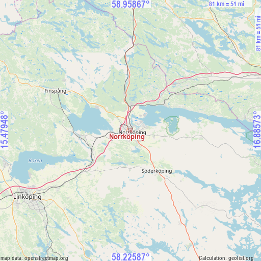
Norrköping GPS coordinates[2]
58° 35' 39.084" North, 16° 10' 57.36" East
| Map corner | latitude | longitude |
|---|---|---|
| Upper-left | 58.95867°, | 15.47948° |
| Center: | 58.59419°, | 16.1826° |
| Lower-right: | 58.22587°, | 16.88573° |
| Map W x H: | 81.5×81.5 km | = 50.6×50.6mi |
| max Lat: | 67.85572° ⇑51% North |
| Norrköping: | 58.59419° |
| min Lat: | ⇓49% South 55.34337° |
| min Long | Norrköping | max Long |
| 11.1712° | 16.1826° | 24.13676° |
| W 63.5%⇐ | ⇒36.5% E |
Elevation
Elevation of Norrköping is 12 m = 39 ft, and this is 70.6 m = 232 ft below average elevation for this country.
| Max E: |
663 m = 2175 ft | 85.7% |
| Avg. | 82.6 m = 271 ft | |
| Norrköping | 12 m = 39 ft | |
Min E: |
-1 m = -3 ft | 14.3% |
See also: Norrköping elevation on elevation.city.
Geographical zone
Norrköping is located in North temperate zone (between Tropic of Cancer and the Arctic Circle). Distance of this North polar circle is 886.1 km =550.6 mi to North.| Distance of | km | miles | from Norrköping |
|---|---|---|---|
| North Pole | 3492 | 2169.8 | to North |
| Arctic Circle | 886.1 | 550.6 | to North |
| Tropic Cancer | 3909.1 | 2429 | to South |
| Equator | 6515.1 | 4048.3 | to South |


Nearby cities:
15 places around Norrköping: (largest is in red/bold)
• Jursla
8.1 km =5 mi,  0°
0°
• Kimstad
13.7 km =8.5 mi,  248°
248°
• Krokek
13.8 km =8.6 mi,  50°
50°
• Lindö
4.6 km =2.9 mi,  57°
57°
• Ljunga
13 km =8.1 mi,  131°
131°
• Lotorp
25.4 km =15.8 mi,  307°
307°
• Norsholm
15.7 km =9.8 mi,  230°
230°
• Ruda
24.5 km =15.2 mi,  280°
280°
• Skärblacka
16.7 km =10.4 mi,  259°
259°
• Strömsfors
12.8 km =8 mi,  41°
41°
• Svärtinge
11.2 km =7 mi, 307°
• Söderköping
15 km =9.3 mi,  147°
147°
• Åby
8.1 km =5 mi, 0°
• Öbonäs
5.7 km =3.5 mi,  175°
175°
• Östra Husby
21.3 km =13.2 mi,  93°
93°
Sources, notices
• [Note1] Compared only with cities in Sweden existing in our database
• [Src1] Map data: © OpenStreetMap contributors (CC-BY-SA)
• [Src2] Other city data from geonames.org with taken over terms of usage.
• [Src3] Geographical zone / Annual Mean Temperature by Robert A. Rohde @ Wikipedia
