Rimbo geodata
Rimbo (Stockholm) is a populated place; located in Sweden in Europe/Stockholm (GMT+2) time zone. With population of 4,882 people, there are 279 cities with bigger population in this country. Compared to other cities in Sweden, 70.4% of cities are located further ↓South; 89.5% of cities are located further ←West and 65.3% of cities have higher elevation than Rimbo. Note1


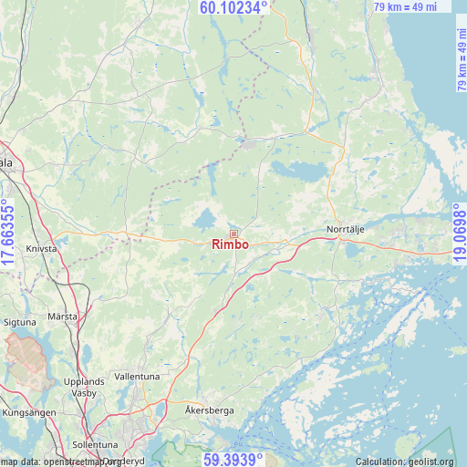
Rimbo GPS coordinates[2]
59° 45' 0" North, 18° 22' 0.012" East
| Map corner | latitude | longitude |
|---|---|---|
| Upper-left | 60.10234°, | 17.66355° |
| Center: | 59.75°, | 18.36667° |
| Lower-right: | 59.3939°, | 19.0698° |
| Map W x H: | 78.8×78.8 km | = 49×49mi |
| max Lat: | 67.85572° ⇑29.6% North |
| Rimbo: | 59.75° |
| min Lat: | ⇓70.4% South 55.34337° |
| min Long | Rimbo | max Long |
| 11.1712° | 18.36667° | 24.13676° |
| W 89.5%⇐ | ⇒10.5% E |
Elevation
Elevation of Rimbo is 30 m = 98 ft, and this is 52.6 m = 173 ft below average elevation for this country.
| Max E: |
663 m = 2175 ft | 65.3% |
| Avg. | 82.6 m = 271 ft | |
| Rimbo | 30 m = 98 ft | |
Min E: |
-1 m = -3 ft | 34.7% |
See also: Sweden elevation on elevation.city.
Geographical zone
Rimbo is located in North temperate zone (between Tropic of Cancer and the Arctic Circle). Distance of this North polar circle is 757.6 km =470.8 mi to North.| Distance of | km | miles | from Rimbo |
|---|---|---|---|
| North Pole | 3363.5 | 2090 | to North |
| Arctic Circle | 757.6 | 470.8 | to North |
| Tropic Cancer | 4037.7 | 2508.9 | to South |
| Equator | 6643.6 | 4128.1 | to South |


Nearby cities:
15 places around Rimbo: (largest is in red/bold)
• Almunge
23.1 km =14.4 mi,  309°
309°
• Bergshamra
19.5 km =12.1 mi,  131°
131°
• Edsbro
17.4 km =10.8 mi,  23°
23°
• Gunsta
31.8 km =19.8 mi,  290°
290°
• Karby
22.6 km =14 mi,  201°
201°
• Knutby
18.5 km =11.5 mi,  342°
342°
• Kårsta
11.7 km =7.3 mi,  206°
206°
• Lindholmen
23.8 km =14.8 mi,  218°
218°
• Länna
26.9 km =16.7 mi,  300°
300°
• Norrtälje
19 km =11.8 mi,  87°
87°
• Nykvarn
6.7 km =4.2 mi,  326°
326°
• Skänninge
21.4 km =13.3 mi, 17°
• Svanberga
19.8 km =12.3 mi,  57°
57°
• Vallentuna
29 km =18 mi, 214°
• Åkersberga
30.3 km =18.8 mi,  187°
187°
Sources, notices
• [Note1] Compared only with cities in Sweden existing in our database
• [Src1] Map data: © OpenStreetMap contributors (CC-BY-SA)
• [Src2] Other city data from geonames.org with taken over terms of usage.
• [Src3] Geographical zone / Annual Mean Temperature by Robert A. Rohde @ Wikipedia
