Norrtälje geodata
Norrtälje (Stockholm) is a seat of a second-order administrative division; located in Sweden in Europe/Stockholm (GMT+2) time zone. With population of 19,365 people, there are 78 cities with bigger population in this country. Compared to other cities in Sweden, 70.5% of cities are located further ↓South; 92% of cities are located further ←West and 84.8% of cities have higher elevation than Norrtälje. Note1


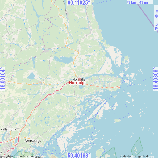
Norrtälje GPS coordinates[2]
59° 45' 28.764" North, 18° 42' 17.856" East
| Map corner | latitude | longitude |
|---|---|---|
| Upper-left | 60.11025°, | 18.00184° |
| Center: | 59.75799°, | 18.70496° |
| Lower-right: | 59.40198°, | 19.40809° |
| Map W x H: | 78.8×78.7 km | = 49×48.9mi |
| max Lat: | 67.85572° ⇑29.5% North |
| Norrtälje: | 59.75799° |
| min Lat: | ⇓70.5% South 55.34337° |
| min Long | Norrtälje | max Long |
| 11.1712° | 18.70496° | 24.13676° |
| W 92%⇐ | ⇒8% E |
Elevation
Elevation of Norrtälje is 13 m = 43 ft, and this is 69.6 m = 228 ft below average elevation for this country.
| Max E: |
663 m = 2175 ft | 84.8% |
| Avg. | 82.6 m = 271 ft | |
| Norrtälje | 13 m = 43 ft | |
Min E: |
-1 m = -3 ft | 15.2% |
See also: Sweden elevation on elevation.city.
Geographical zone
Norrtälje is located in North temperate zone (between Tropic of Cancer and the Arctic Circle). Distance of this North polar circle is 756.7 km =470.2 mi to North.| Distance of | km | miles | from Norrtälje |
|---|---|---|---|
| North Pole | 3362.6 | 2089.4 | to North |
| Arctic Circle | 756.7 | 470.2 | to North |
| Tropic Cancer | 4038.5 | 2509.4 | to South |
| Equator | 6644.5 | 4128.7 | to South |


Nearby cities:
15 places around Norrtälje: (largest is in red/bold)
• Bergshamra
14.4 km =8.9 mi,  197°
197°
• Edsbro
19.2 km =11.9 mi,  321°
321°
• Gräddö
18.4 km =11.4 mi,  86°
86°
• Hallstavik
33 km =20.5 mi,  349°
349°
• Karby
35 km =21.7 mi,  231°
231°
• Knutby
29.7 km =18.5 mi,  304°
304°
• Kårsta
26.7 km =16.6 mi,  244°
244°
• Nykvarn
23.1 km =14.4 mi,  281°
281°
• Rimbo
19 km =11.8 mi,  267°
267°
• Rörvik
19.2 km =11.9 mi,  34°
34°
• Skänninge
23.1 km =14.4 mi,  327°
327°
• Strömma
17.4 km =10.8 mi,  108°
108°
• Svanberga
9.8 km =6.1 mi, 347°
• Älmsta
23.8 km =14.8 mi,  12°
12°
• Åkersberga
38.5 km =23.9 mi,  216°
216°
Sources, notices
• [Note1] Compared only with cities in Sweden existing in our database
• [Src1] Map data: © OpenStreetMap contributors (CC-BY-SA)
• [Src2] Other city data from geonames.org with taken over terms of usage.
• [Src3] Geographical zone / Annual Mean Temperature by Robert A. Rohde @ Wikipedia
