Grums geodata
Grums (Värmland) is a seat of a second-order administrative division; located in Sweden in Europe/Stockholm (GMT+2) time zone. With population of 5,040 people, there are 269 cities with bigger population in this country. Compared to other cities in Sweden, 62.2% of cities are located further ↓South; 77.1% of cities are located further →East and 57.5% of cities have lower elevation than Grums. Note1
Administrative division(s):
- Level 1: Värmland
- Level 2: Grums Kommun
- Level 3: Grums
- Level 4: Grums socken


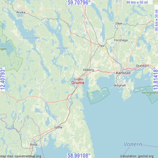
Grums GPS coordinates[2]
59° 21' 5.076" North, 13° 6' 39.78" East
| Map corner | latitude | longitude |
|---|---|---|
| Upper-left | 59.70796°, | 12.40793° |
| Center: | 59.35141°, | 13.11105° |
| Lower-right: | 58.99108°, | 13.81418° |
| Map W x H: | 79.7×79.7 km | = 49.5×49.5mi |
| max Lat: | 67.85572° ⇑37.8% North |
| Grums: | 59.35141° |
| min Lat: | ⇓62.2% South 55.34337° |
| min Long | Grums | max Long |
| 11.1712° | 13.11105° | 24.13676° |
| W 22.9%⇐ | ⇒77.1% E |
Elevation
Elevation of Grums is 64 m = 210 ft, and this is 18.6 m = 61 ft below average elevation for this country.
| Max E: |
663 m = 2175 ft | 42.5% |
| Avg. | 82.6 m = 271 ft | |
| Grums | 64 m = 210 ft | |
Min E: |
-1 m = -3 ft | 57.5% |
See also: Sweden elevation on elevation.city.
Geographical zone
Grums is located in North temperate zone (between Tropic of Cancer and the Arctic Circle). Distance of this North polar circle is 801.9 km =498.3 mi to North.| Distance of | km | miles | from Grums |
|---|---|---|---|
| North Pole | 3407.8 | 2117.5 | to North |
| Arctic Circle | 801.9 | 498.3 | to North |
| Tropic Cancer | 3993.3 | 2481.3 | to South |
| Equator | 6599.3 | 4100.6 | to South |


Nearby cities:
15 places around Grums: (largest is in red/bold)
• Alster
28.9 km =18 mi,  79°
79°
• Deje
34.6 km =21.5 mi,  36°
36°
• Edsvalla
10.8 km =6.7 mi,  30°
30°
• Forshaga
28.5 km =17.7 mi,  47°
47°
• Gärsnäs
14 km =8.7 mi,  301°
301°
• Karlstad
22.5 km =14 mi, 82°
• Kil
20.3 km =12.6 mi, 34°
• Råtorp
22.3 km =13.9 mi, 75°
• Skattkärr
32.4 km =20.1 mi, 77°
• Skoghall
20.3 km =12.6 mi,  98°
98°
• Skåre
20.4 km =12.7 mi,  63°
63°
• Slottsbron
3.2 km =2 mi,  188°
188°
• Säffle
26.5 km =16.5 mi,  203°
203°
• Vallargärdet
30.3 km =18.8 mi, 62°
• Vålberg
6.2 km =3.9 mi, 43°
Sources, notices
• [Note1] Compared only with cities in Sweden existing in our database
• [Src1] Map data: © OpenStreetMap contributors (CC-BY-SA)
• [Src2] Other city data from geonames.org with taken over terms of usage.
• [Src3] Geographical zone / Annual Mean Temperature by Robert A. Rohde @ Wikipedia
