Råtorp geodata
Råtorp (Värmland) is a section of populated place; located in Sweden in Europe/Stockholm (GMT+2) time zone. With population of 3,287 people, there are 380 cities with bigger population in this country. Compared to other cities in Sweden, 64% of cities are located further ↓South; 71.5% of cities are located further →East and 51.8% of cities have lower elevation than Råtorp. Note1
Administrative division(s):
- Level 1: Värmland
- Level 2: Karlstads Kommun
- Level 3: Karlstads domkyrkoförs.
- Level 4: Karlstad socken


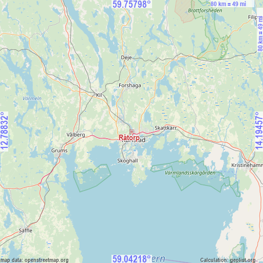
Råtorp GPS coordinates[2]
59° 24' 7.092" North, 13° 29' 29.184" East
| Map corner | latitude | longitude |
|---|---|---|
| Upper-left | 59.75798°, | 12.78832° |
| Center: | 59.40197°, | 13.49144° |
| Lower-right: | 59.04218°, | 14.19457° |
| Map W x H: | 79.6×79.6 km | = 49.5×49.5mi |
| max Lat: | 67.85572° ⇑36% North |
| Råtorp: | 59.40197° |
| min Lat: | ⇓64% South 55.34337° |
| min Long | Råtorp | max Long |
| 11.1712° | 13.49144° | 24.13676° |
| W 28.5%⇐ | ⇒71.5% E |
Elevation
Elevation of Råtorp is 53 m = 174 ft, and this is 29.6 m = 97 ft below average elevation for this country.
| Max E: |
663 m = 2175 ft | 48.2% |
| Avg. | 82.6 m = 271 ft | |
| Råtorp | 53 m = 174 ft | |
Min E: |
-1 m = -3 ft | 51.8% |
See also: Sweden elevation on elevation.city.
Geographical zone
Råtorp is located in North temperate zone (between Tropic of Cancer and the Arctic Circle). Distance of this North polar circle is 796.3 km =494.8 mi to North.| Distance of | km | miles | from Råtorp |
|---|---|---|---|
| North Pole | 3402.2 | 2114 | to North |
| Arctic Circle | 796.3 | 494.8 | to North |
| Tropic Cancer | 3999 | 2484.9 | to South |
| Equator | 6604.9 | 4104.1 | to South |


Nearby cities:
15 places around Råtorp: (largest is in red/bold)
• Alster
6.9 km =4.3 mi,  93°
93°
• Deje
22.4 km =13.9 mi,  357°
357°
• Edsvalla
16.4 km =10.2 mi,  282°
282°
• Forshaga
13.7 km =8.5 mi, 357°
• Grums
22.3 km =13.9 mi,  255°
255°
• Karlstad
2.6 km =1.6 mi,  164°
164°
• Kil
15 km =9.3 mi,  317°
317°
• Molkom
25.6 km =15.9 mi,  30°
30°
• Skattkärr
10.2 km =6.3 mi,  83°
83°
• Skoghall
8.9 km =5.5 mi,  189°
189°
• Skåre
4.8 km =3 mi, 316°
• Slottsbron
23.7 km =14.7 mi,  248°
248°
• Vallargärdet
9.9 km =6.2 mi, 32°
• Väse
20.5 km =12.7 mi,  96°
96°
• Vålberg
17.3 km =10.7 mi,  266°
266°
Sources, notices
• [Note1] Compared only with cities in Sweden existing in our database
• [Src1] Map data: © OpenStreetMap contributors (CC-BY-SA)
• [Src2] Other city data from geonames.org with taken over terms of usage.
• [Src3] Geographical zone / Annual Mean Temperature by Robert A. Rohde @ Wikipedia
