Forshaga geodata
Forshaga (Värmland) is a seat of a second-order administrative division; located in Sweden in Europe/Stockholm (GMT+2) time zone. With population of 6,361 people, there are 221 cities with bigger population in this country. Compared to other cities in Sweden, 66.8% of cities are located further ↓South; 71.8% of cities are located further →East and 57% of cities have lower elevation than Forshaga. Note1


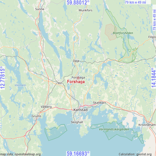
Forshaga GPS coordinates[2]
59° 31' 31.476" North, 13° 28' 52.572" East
| Map corner | latitude | longitude |
|---|---|---|
| Upper-left | 59.88012°, | 12.77815° |
| Center: | 59.52541°, | 13.48127° |
| Lower-right: | 59.16693°, | 14.1844° |
| Map W x H: | 79.3×79.3 km | = 49.3×49.3mi |
| max Lat: | 67.85572° ⇑33.2% North |
| Forshaga: | 59.52541° |
| min Lat: | ⇓66.8% South 55.34337° |
| min Long | Forshaga | max Long |
| 11.1712° | 13.48127° | 24.13676° |
| W 28.2%⇐ | ⇒71.8% E |
Elevation
Elevation of Forshaga is 63 m = 207 ft, and this is 19.6 m = 64 ft below average elevation for this country.
| Max E: |
663 m = 2175 ft | 43% |
| Avg. | 82.6 m = 271 ft | |
| Forshaga | 63 m = 207 ft | |
Min E: |
-1 m = -3 ft | 57% |
See also: Sweden elevation on elevation.city.
Geographical zone
Forshaga is located in North temperate zone (between Tropic of Cancer and the Arctic Circle). Distance of this North polar circle is 782.6 km =486.3 mi to North.| Distance of | km | miles | from Forshaga |
|---|---|---|---|
| North Pole | 3388.5 | 2105.5 | to North |
| Arctic Circle | 782.6 | 486.3 | to North |
| Tropic Cancer | 4012.7 | 2493.4 | to South |
| Equator | 6618.6 | 4112.6 | to South |


Nearby cities:
15 places around Forshaga: (largest is in red/bold)
• Alster
16 km =9.9 mi,  152°
152°
• Deje
8.6 km =5.3 mi,  356°
356°
• Edsvalla
18.4 km =11.4 mi,  236°
236°
• Grums
28.5 km =17.7 mi,  227°
227°
• Karlstad
16.3 km =10.1 mi,  175°
175°
• Kil
9.8 km =6.1 mi,  254°
254°
• Molkom
15.9 km =9.9 mi,  58°
58°
• Råtorp
13.7 km =8.5 mi, 177°
• Skattkärr
16.5 km =10.3 mi,  139°
139°
• Skoghall
22.5 km =14 mi, 182°
• Skåre
10.6 km =6.6 mi,  194°
194°
• Slottsbron
31.1 km =19.3 mi,  223°
223°
• Vallargärdet
7.9 km =4.9 mi,  132°
132°
• Väse
26.2 km =16.3 mi, 127°
• Vålberg
22.4 km =13.9 mi, 228°
Sources, notices
• [Note1] Compared only with cities in Sweden existing in our database
• [Src1] Map data: © OpenStreetMap contributors (CC-BY-SA)
• [Src2] Other city data from geonames.org with taken over terms of usage.
• [Src3] Geographical zone / Annual Mean Temperature by Robert A. Rohde @ Wikipedia
