Vallargärdet geodata
Vallargärdet (Värmland) is a populated place; located in Sweden in Europe/Stockholm (GMT+2) time zone. With population of 648 people, there are 1122 cities with bigger population in this country. Compared to other cities in Sweden, 65.8% of cities are located further ↓South; 69.7% of cities are located further →East and 57% of cities have lower elevation than Vallargärdet. Note1
Administrative division(s):
- Level 1: Värmland
- Level 2: Karlstads Kommun
- Level 3: Alster-Nyedsbygden
- Level 4: Alster socken


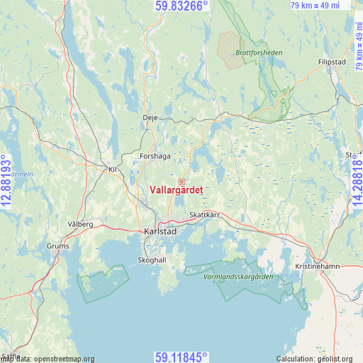
Vallargärdet GPS coordinates[2]
59° 28' 38.784" North, 13° 35' 6.18" East
| Map corner | latitude | longitude |
|---|---|---|
| Upper-left | 59.83266°, | 12.88193° |
| Center: | 59.47744°, | 13.58505° |
| Lower-right: | 59.11845°, | 14.28818° |
| Map W x H: | 79.4×79.4 km | = 49.3×49.3mi |
| max Lat: | 67.85572° ⇑34.2% North |
| Vallargärdet: | 59.47744° |
| min Lat: | ⇓65.8% South 55.34337° |
| min Long | Vallargärdet | max Long |
| 11.1712° | 13.58505° | 24.13676° |
| W 30.3%⇐ | ⇒69.7% E |
Elevation
Elevation of Vallargärdet is 63 m = 207 ft, and this is 19.6 m = 64 ft below average elevation for this country.
| Max E: |
663 m = 2175 ft | 43% |
| Avg. | 82.6 m = 271 ft | |
| Vallargärdet | 63 m = 207 ft | |
Min E: |
-1 m = -3 ft | 57% |
See also: Sweden elevation on elevation.city.
Geographical zone
Vallargärdet is located in North temperate zone (between Tropic of Cancer and the Arctic Circle). Distance of this North polar circle is 787.9 km =489.6 mi to North.| Distance of | km | miles | from Vallargärdet |
|---|---|---|---|
| North Pole | 3393.8 | 2108.8 | to North |
| Arctic Circle | 787.9 | 489.6 | to North |
| Tropic Cancer | 4007.4 | 2490.1 | to South |
| Equator | 6613.3 | 4109.3 | to South |


Nearby cities:
15 places around Vallargärdet: (largest is in red/bold)
• Alster
8.9 km =5.5 mi,  169°
169°
• Deje
15.3 km =9.5 mi,  335°
335°
• Edsvalla
21.8 km =13.5 mi,  257°
257°
• Forshaga
7.9 km =4.9 mi,  312°
312°
• Grums
30.3 km =18.8 mi,  242°
242°
• Karlstad
11.8 km =7.3 mi,  202°
202°
• Kil
15.6 km =9.7 mi,  280°
280°
• Molkom
15.7 km =9.8 mi,  29°
29°
• Råtorp
9.9 km =6.2 mi,  212°
212°
• Skattkärr
8.7 km =5.4 mi,  146°
146°
• Skoghall
18.4 km =11.4 mi, 201°
• Skåre
9.9 km =6.2 mi, 240°
• Slottsbron
32.3 km =20.1 mi, 237°
• Väse
18.4 km =11.4 mi,  125°
125°
• Vålberg
24.5 km =15.2 mi,  247°
247°
Sources, notices
• [Note1] Compared only with cities in Sweden existing in our database
• [Src1] Map data: © OpenStreetMap contributors (CC-BY-SA)
• [Src2] Other city data from geonames.org with taken over terms of usage.
• [Src3] Geographical zone / Annual Mean Temperature by Robert A. Rohde @ Wikipedia
