Skoghall geodata
Skoghall (Värmland) is a seat of a second-order administrative division; located in Sweden in Europe/Stockholm (GMT+2) time zone. With population of 13,605 people, there are 114 cities with bigger population in this country. Compared to other cities in Sweden, 60.8% of cities are located further ↓South; 72% of cities are located further →East and 53.7% of cities have lower elevation than Skoghall. Note1


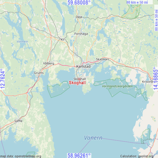
Skoghall GPS coordinates[2]
59° 19' 23.664" North, 13° 27' 55.872" East
| Map corner | latitude | longitude |
|---|---|---|
| Upper-left | 59.68008°, | 12.7624° |
| Center: | 59.32324°, | 13.46552° |
| Lower-right: | 58.96261°, | 14.16865° |
| Map W x H: | 79.8×79.8 km | = 49.6×49.6mi |
| max Lat: | 67.85572° ⇑39.2% North |
| Skoghall: | 59.32324° |
| min Lat: | ⇓60.8% South 55.34337° |
| min Long | Skoghall | max Long |
| 11.1712° | 13.46552° | 24.13676° |
| W 28%⇐ | ⇒72% E |
Elevation
Elevation of Skoghall is 56 m = 184 ft, and this is 26.6 m = 87 ft below average elevation for this country.
| Max E: |
663 m = 2175 ft | 46.3% |
| Avg. | 82.6 m = 271 ft | |
| Skoghall | 56 m = 184 ft | |
Min E: |
-1 m = -3 ft | 53.7% |
See also: Sweden elevation on elevation.city.
Geographical zone
Skoghall is located in North temperate zone (between Tropic of Cancer and the Arctic Circle). Distance of this North polar circle is 805 km =500.2 mi to North.| Distance of | km | miles | from Skoghall |
|---|---|---|---|
| North Pole | 3410.9 | 2119.4 | to North |
| Arctic Circle | 805 | 500.2 | to North |
| Tropic Cancer | 3990.2 | 2479.4 | to South |
| Equator | 6596.1 | 4098.6 | to South |


Nearby cities:
15 places around Skoghall: (largest is in red/bold)
• Alster
11.9 km =7.4 mi,  45°
45°
• Deje
31.1 km =19.3 mi,  0°
0°
• Edsvalla
19.1 km =11.9 mi,  310°
310°
• Forshaga
22.5 km =14 mi, 2°
• Grums
20.3 km =12.6 mi,  278°
278°
• Gärsnäs
33.7 km =20.9 mi,  287°
287°
• Karlstad
6.6 km =4.1 mi,  19°
19°
• Kil
21.7 km =13.5 mi,  336°
336°
• Råtorp
8.9 km =5.5 mi,  9°
9°
• Skattkärr
15.3 km =9.5 mi, 49°
• Skåre
12.4 km =7.7 mi,  351°
351°
• Slottsbron
20.6 km =12.8 mi,  269°
269°
• Vallargärdet
18.4 km =11.4 mi, 21°
• Väse
22.8 km =14.2 mi,  73°
73°
• Vålberg
17.5 km =10.9 mi,  295°
295°
Sources, notices
• [Note1] Compared only with cities in Sweden existing in our database
• [Src1] Map data: © OpenStreetMap contributors (CC-BY-SA)
• [Src2] Other city data from geonames.org with taken over terms of usage.
• [Src3] Geographical zone / Annual Mean Temperature by Robert A. Rohde @ Wikipedia
