Boxholm geodata
Boxholm (Östergötland) is a seat of a second-order administrative division; located in Sweden in Europe/Stockholm (GMT+2) time zone. With population of 3,269 people, there are 383 cities with bigger population in this country. Compared to other cities in Sweden, 58% of cities are located further ↑North; 50.2% of cities are located further ←West and 80.4% of cities have lower elevation than Boxholm. Note1


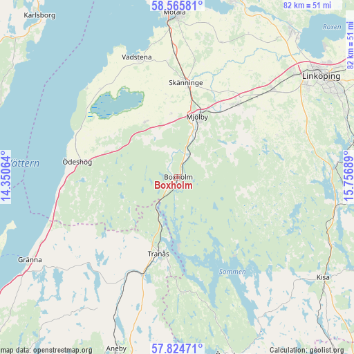
Boxholm GPS coordinates[2]
58° 11' 49.884" North, 15° 3' 13.536" East
| Map corner | latitude | longitude |
|---|---|---|
| Upper-left | 58.56581°, | 14.35064° |
| Center: | 58.19719°, | 15.05376° |
| Lower-right: | 57.82471°, | 15.75689° |
| Map W x H: | 82.4×82.4 km | = 51.2×51.2mi |
| max Lat: | 67.85572° ⇑58% North |
| Boxholm: | 58.19719° |
| min Lat: | ⇓42% South 55.34337° |
| min Long | Boxholm | max Long |
| 11.1712° | 15.05376° | 24.13676° |
| W 50.2%⇐ | ⇒49.8% E |
Elevation
Elevation of Boxholm is 147 m = 482 ft, and this is 64.4 m = 211 ft above average elevation for this country.
| Max E: |
663 m = 2175 ft | 19.6% |
| Boxholm | 147 m 482 ft | |
| Avg. | 82.6 m = 271 ft | |
Min E: |
-1 m = -3 ft | 80.4% |
See also: Sweden elevation on elevation.city.
Geographical zone
Boxholm is located in North temperate zone (between Tropic of Cancer and the Arctic Circle). Distance of this North polar circle is 930.3 km =578.1 mi to North.| Distance of | km | miles | from Boxholm |
|---|---|---|---|
| North Pole | 3536.1 | 2197.2 | to North |
| Arctic Circle | 930.3 | 578.1 | to North |
| Tropic Cancer | 3865 | 2401.6 | to South |
| Equator | 6470.9 | 4020.8 | to South |


Nearby cities:
15 places around Boxholm: (largest is in red/bold)
• Herrestad
25.5 km =15.8 mi,  324°
324°
• Lidhult
34.2 km =21.3 mi,  143°
143°
• Malmslätt
36 km =22.4 mi,  48°
48°
• Mantorp
21.7 km =13.5 mi,  38°
38°
• Mjölby
14.9 km =9.3 mi,  15°
15°
• Rimforsa
37.7 km =23.4 mi,  100°
100°
• Skänninge
22 km =13.7 mi,  5°
5°
• Slaka
34.6 km =21.5 mi,  56°
56°
• Sommen
8.7 km =5.4 mi,  215°
215°
• Stenstorp
31.8 km =19.8 mi,  1°
1°
• Tranås
18.3 km =11.4 mi,  194°
194°
• Vadstena
29.6 km =18.4 mi,  341°
341°
• Vikingstad
30.3 km =18.8 mi, 46°
• Väderstad
15.5 km =9.6 mi,  328°
328°
• Ödeshög
23.7 km =14.7 mi,  278°
278°
Sources, notices
• [Note1] Compared only with cities in Sweden existing in our database
• [Src1] Map data: © OpenStreetMap contributors (CC-BY-SA)
• [Src2] Other city data from geonames.org with taken over terms of usage.
• [Src3] Geographical zone / Annual Mean Temperature by Robert A. Rohde @ Wikipedia
