Rimforsa geodata
Rimforsa (Östergötland) is a populated place; located in Sweden in Europe/Stockholm (GMT+2) time zone. With population of 2,259 people, there are 483 cities with bigger population in this country. Compared to other cities in Sweden, 58.6% of cities are located further ↑North; 58% of cities are located further ←West and 69% of cities have lower elevation than Rimforsa. Note1


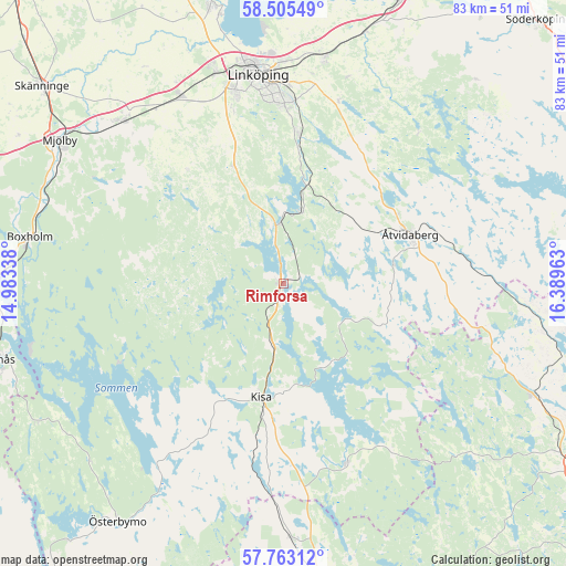
Rimforsa GPS coordinates[2]
58° 8' 10.464" North, 15° 41' 11.4" East
| Map corner | latitude | longitude |
|---|---|---|
| Upper-left | 58.50549°, | 14.98338° |
| Center: | 58.13624°, | 15.6865° |
| Lower-right: | 57.76312°, | 16.38963° |
| Map W x H: | 82.5×82.5 km | = 51.3×51.3mi |
| max Lat: | 67.85572° ⇑58.6% North |
| Rimforsa: | 58.13624° |
| min Lat: | ⇓41.4% South 55.34337° |
| min Long | Rimforsa | max Long |
| 11.1712° | 15.6865° | 24.13676° |
| W 58%⇐ | ⇒42% E |
Elevation
Elevation of Rimforsa is 95 m = 312 ft, and this is 12.4 m = 41 ft above average elevation for this country.
| Max E: |
663 m = 2175 ft | 31% |
| Rimforsa | 95 m 312 ft | |
| Avg. | 82.6 m = 271 ft | |
Min E: |
-1 m = -3 ft | 69% |
See also: Sweden elevation on elevation.city.
Geographical zone
Rimforsa is located in North temperate zone (between Tropic of Cancer and the Arctic Circle). Distance of this North polar circle is 937 km =582.2 mi to North.| Distance of | km | miles | from Rimforsa |
|---|---|---|---|
| North Pole | 3542.9 | 2201.5 | to North |
| Arctic Circle | 937 | 582.2 | to North |
| Tropic Cancer | 3858.2 | 2397.4 | to South |
| Equator | 6464.1 | 4016.6 | to South |


Nearby cities:
15 places around Rimforsa: (largest is in red/bold)
• Askeby
31.6 km =19.6 mi,  17°
17°
• Bestorp
11.1 km =6.9 mi,  14°
14°
• Grebo
21.3 km =13.2 mi,  30°
30°
• Horn
27.7 km =17.2 mi,  161°
161°
• Kisa
16.8 km =10.4 mi,  190°
190°
• Lidhult
26.7 km =16.6 mi,  219°
219°
• Linghem
33.5 km =20.8 mi, 9°
• Linköping
30.8 km =19.1 mi,  352°
352°
• Malmslätt
32.1 km =19.9 mi,  341°
341°
• Mantorp
33.5 km =20.8 mi,  315°
315°
• Slaka
26.8 km =16.7 mi, 342°
• Sturefors
22.1 km =13.7 mi, 7°
• Tallboda
32.1 km =19.9 mi,  359°
359°
• Vikingstad
31.2 km =19.4 mi,  331°
331°
• Åtvidaberg
19.6 km =12.2 mi,  68°
68°
Sources, notices
• [Note1] Compared only with cities in Sweden existing in our database
• [Src1] Map data: © OpenStreetMap contributors (CC-BY-SA)
• [Src2] Other city data from geonames.org with taken over terms of usage.
• [Src3] Geographical zone / Annual Mean Temperature by Robert A. Rohde @ Wikipedia
