Vadstena geodata
Vadstena (Östergötland) is a seat of a second-order administrative division; located in Sweden in Europe/Stockholm (GMT+2) time zone. With population of 5,674 people, there are 248 cities with bigger population in this country. Compared to other cities in Sweden, 53.7% of cities are located further ↑North; 52.6% of cities are located further →East and 69.3% of cities have lower elevation than Vadstena. Note1


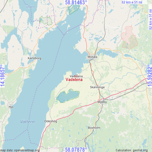
Vadstena GPS coordinates[2]
58° 26' 55.068" North, 14° 53' 22.884" East
| Map corner | latitude | longitude |
|---|---|---|
| Upper-left | 58.81463°, | 14.18657° |
| Center: | 58.44863°, | 14.88969° |
| Lower-right: | 58.07878°, | 15.59282° |
| Map W x H: | 81.8×81.8 km | = 50.8×50.8mi |
| max Lat: | 67.85572° ⇑53.7% North |
| Vadstena: | 58.44863° |
| min Lat: | ⇓46.3% South 55.34337° |
| min Long | Vadstena | max Long |
| 11.1712° | 14.88969° | 24.13676° |
| W 47.4%⇐ | ⇒52.6% E |
Elevation
Elevation of Vadstena is 97 m = 318 ft, and this is 14.4 m = 47 ft above average elevation for this country.
| Max E: |
663 m = 2175 ft | 30.7% |
| Vadstena | 97 m 318 ft | |
| Avg. | 82.6 m = 271 ft | |
Min E: |
-1 m = -3 ft | 69.3% |
See also: Sweden elevation on elevation.city.
Geographical zone
Vadstena is located in North temperate zone (between Tropic of Cancer and the Arctic Circle). Distance of this North polar circle is 902.3 km =560.7 mi to North.| Distance of | km | miles | from Vadstena |
|---|---|---|---|
| North Pole | 3508.2 | 2179.9 | to North |
| Arctic Circle | 902.3 | 560.7 | to North |
| Tropic Cancer | 3893 | 2419 | to South |
| Equator | 6498.9 | 4038.2 | to South |


Nearby cities:
15 places around Vadstena: (largest is in red/bold)
• Borensberg
26.4 km =16.4 mi,  60°
60°
• Boxholm
29.6 km =18.4 mi,  161°
161°
• Fagersanna
34.4 km =21.4 mi,  273°
273°
• Herrestad
8.9 km =5.5 mi,  215°
215°
• Karlsborg
24.4 km =15.2 mi,  293°
293°
• Mantorp
25.4 km =15.8 mi,  115°
115°
• Mjölby
19.3 km =12 mi,  135°
135°
• Motala
13 km =8.1 mi,  40°
40°
• Mölltorp
29 km =18 mi,  281°
281°
• Ryd
26.7 km =16.6 mi,  24°
24°
• Skänninge
13 km =8.1 mi, 117°
• Stenstorp
11 km =6.8 mi,  69°
69°
• Vikingstad
32.4 km =20.1 mi,  103°
103°
• Väderstad
14.8 km =9.2 mi,  173°
173°
• Ödeshög
28 km =17.4 mi,  209°
209°
Sources, notices
• [Note1] Compared only with cities in Sweden existing in our database
• [Src1] Map data: © OpenStreetMap contributors (CC-BY-SA)
• [Src2] Other city data from geonames.org with taken over terms of usage.
• [Src3] Geographical zone / Annual Mean Temperature by Robert A. Rohde @ Wikipedia
