Väderstad geodata
Väderstad (Östergötland) is a populated place; located in Sweden in Europe/Stockholm (GMT+2) time zone. With population of 573 people, there are 1206 cities with bigger population in this country. Compared to other cities in Sweden, 56.4% of cities are located further ↑North; 52.3% of cities are located further →East and 73.7% of cities have lower elevation than Väderstad. Note1


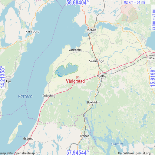
Väderstad GPS coordinates[2]
58° 19' 0.012" North, 14° 55' 0.012" East
| Map corner | latitude | longitude |
|---|---|---|
| Upper-left | 58.68404°, | 14.21355° |
| Center: | 58.31667°, | 14.91667° |
| Lower-right: | 57.94544°, | 15.6198° |
| Map W x H: | 82.1×82.1 km | = 51×51mi |
| max Lat: | 67.85572° ⇑56.4% North |
| Väderstad: | 58.31667° |
| min Lat: | ⇓43.6% South 55.34337° |
| min Long | Väderstad | max Long |
| 11.1712° | 14.91667° | 24.13676° |
| W 47.7%⇐ | ⇒52.3% E |
Elevation
Elevation of Väderstad is 112 m = 367 ft, and this is 29.4 m = 96 ft above average elevation for this country.
| Max E: |
663 m = 2175 ft | 26.3% |
| Väderstad | 112 m 367 ft | |
| Avg. | 82.6 m = 271 ft | |
Min E: |
-1 m = -3 ft | 73.7% |
See also: Sweden elevation on elevation.city.
Geographical zone
Väderstad is located in North temperate zone (between Tropic of Cancer and the Arctic Circle). Distance of this North polar circle is 917 km =569.8 mi to North.| Distance of | km | miles | from Väderstad |
|---|---|---|---|
| North Pole | 3522.9 | 2189 | to North |
| Arctic Circle | 917 | 569.8 | to North |
| Tropic Cancer | 3878.3 | 2409.9 | to South |
| Equator | 6484.2 | 4029.1 | to South |


Nearby cities:
15 places around Väderstad: (largest is in red/bold)
• Borensberg
35 km =21.7 mi,  37°
37°
• Boxholm
15.5 km =9.6 mi,  148°
148°
• Herrestad
10.1 km =6.3 mi,  317°
317°
• Karlsborg
34.3 km =21.3 mi, 315°
• Mantorp
21.7 km =13.5 mi,  80°
80°
• Mjölby
12.1 km =7.5 mi,  85°
85°
• Motala
25.5 km =15.8 mi,  15°
15°
• Mölltorp
36.3 km =22.6 mi,  304°
304°
• Skänninge
13.1 km =8.1 mi,  48°
48°
• Sommen
20.6 km =12.8 mi,  171°
171°
• Stenstorp
20.5 km =12.7 mi,  25°
25°
• Tranås
31.3 km =19.4 mi, 173°
• Vadstena
14.8 km =9.2 mi,  353°
353°
• Vikingstad
31 km =19.3 mi, 76°
• Ödeshög
18.2 km =11.3 mi,  237°
237°
Sources, notices
• [Note1] Compared only with cities in Sweden existing in our database
• [Src1] Map data: © OpenStreetMap contributors (CC-BY-SA)
• [Src2] Other city data from geonames.org with taken over terms of usage.
• [Src3] Geographical zone / Annual Mean Temperature by Robert A. Rohde @ Wikipedia
