Vetlanda geodata
Vetlanda (Jönköping) is a seat of a second-order administrative division; located in Sweden in Europe/Stockholm (GMT+2) time zone. With population of 13,430 people, there are 115 cities with bigger population in this country. Compared to other cities in Sweden, 72.7% of cities are located further ↑North; 50.6% of cities are located further ←West and 88.4% of cities have lower elevation than Vetlanda. Note1


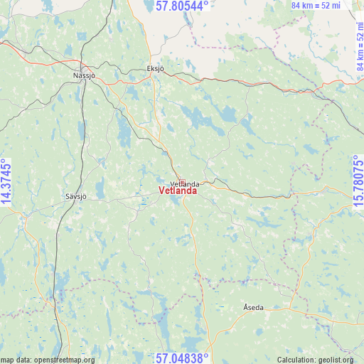
Vetlanda GPS coordinates[2]
57° 25' 43.932" North, 15° 4' 39.432" East
| Map corner | latitude | longitude |
|---|---|---|
| Upper-left | 57.80544°, | 14.3745° |
| Center: | 57.42887°, | 15.07762° |
| Lower-right: | 57.04838°, | 15.78075° |
| Map W x H: | 84.2×84.2 km | = 52.3×52.3mi |
| max Lat: | 67.85572° ⇑72.7% North |
| Vetlanda: | 57.42887° |
| min Lat: | ⇓27.3% South 55.34337° |
| min Long | Vetlanda | max Long |
| 11.1712° | 15.07762° | 24.13676° |
| W 50.6%⇐ | ⇒49.4% E |
Elevation
Elevation of Vetlanda is 187 m = 614 ft, and this is 104.4 m = 343 ft above average elevation for this country.
| Max E: |
663 m = 2175 ft | 11.6% |
| Vetlanda | 187 m 614 ft | |
| Avg. | 82.6 m = 271 ft | |
Min E: |
-1 m = -3 ft | 88.4% |
See also: Sweden elevation on elevation.city.
Geographical zone
Vetlanda is located in North temperate zone (between Tropic of Cancer and the Arctic Circle). Distance of this North polar circle is 1015.7 km =631.1 mi to North.| Distance of | km | miles | from Vetlanda |
|---|---|---|---|
| North Pole | 3621.6 | 2250.4 | to North |
| Arctic Circle | 1015.7 | 631.1 | to North |
| Tropic Cancer | 3779.6 | 2348.5 | to South |
| Equator | 6385.5 | 3967.8 | to South |


Nearby cities:
15 places around Vetlanda: (largest is in red/bold)
• Bodafors
23.9 km =14.9 mi,  289°
289°
• Burseryd
18.9 km =11.7 mi,  248°
248°
• Ekenässjön
7.7 km =4.8 mi,  334°
334°
• Eksjö
27.2 km =16.9 mi,  346°
346°
• Holsbybrunn
7.3 km =4.5 mi,  86°
86°
• Hällaryd
6.8 km =4.2 mi,  51°
51°
• Järnforsen
32.3 km =20.1 mi, 92°
• Korsberga
14.3 km =8.9 mi,  168°
168°
• Landsbro
12.7 km =7.9 mi,  236°
236°
• Myresjö
8.4 km =5.2 mi,  234°
234°
• Skruv
31.5 km =19.6 mi, 170°
• Stockaryd
31.6 km =19.6 mi, 246°
• Sävsjö
25 km =15.5 mi,  263°
263°
• Virserum
32.8 km =20.4 mi,  112°
112°
• Åseda
32.9 km =20.4 mi,  150°
150°
Sources, notices
• [Note1] Compared only with cities in Sweden existing in our database
• [Src1] Map data: © OpenStreetMap contributors (CC-BY-SA)
• [Src2] Other city data from geonames.org with taken over terms of usage.
• [Src3] Geographical zone / Annual Mean Temperature by Robert A. Rohde @ Wikipedia
