Bjuv geodata
Bjuv (Skåne) is a seat of a second-order administrative division; located in Sweden in Europe/Stockholm (GMT+2) time zone. With population of 10,602 people, there are 143 cities with bigger population in this country. Compared to other cities in Sweden, 90.9% of cities are located further ↑North; 82.3% of cities are located further →East and 71.8% of cities have higher elevation than Bjuv. Note1


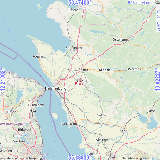
Bjuv GPS coordinates[2]
56° 5' 1.392" North, 12° 55' 8.904" East
| Map corner | latitude | longitude |
|---|---|---|
| Upper-left | 56.47406°, | 12.21602° |
| Center: | 56.08372°, | 12.91914° |
| Lower-right: | 55.68939°, | 13.62227° |
| Map W x H: | 87.2×87.2 km | = 54.2×54.2mi |
| max Lat: | 67.85572° ⇑90.9% North |
| Bjuv: | 56.08372° |
| min Lat: | ⇓9.1% South 55.34337° |
| min Long | Bjuv | max Long |
| 11.1712° | 12.91914° | 24.13676° |
| W 17.7%⇐ | ⇒82.3% E |
Elevation
Elevation of Bjuv is 23 m = 75 ft, and this is 59.6 m = 196 ft below average elevation for this country.
| Max E: |
663 m = 2175 ft | 71.8% |
| Avg. | 82.6 m = 271 ft | |
| Bjuv | 23 m = 75 ft | |
Min E: |
-1 m = -3 ft | 28.2% |
See also: Sweden elevation on elevation.city.
Geographical zone
Bjuv is located in North temperate zone (between Tropic of Cancer and the Arctic Circle). Distance of this North polar circle is 1165.2 km =724 mi to North.| Distance of | km | miles | from Bjuv |
|---|---|---|---|
| North Pole | 3771.1 | 2343.3 | to North |
| Arctic Circle | 1165.2 | 724 | to North |
| Tropic Cancer | 3630 | 2255.6 | to South |
| Equator | 6235.9 | 3874.8 | to South |


Nearby cities:
15 places around Bjuv: (largest is in red/bold)
• Billesholm
6.3 km =3.9 mi,  126°
126°
• Björnås
5.4 km =3.4 mi,  31°
31°
• Bårslöv
10.9 km =6.8 mi,  220°
220°
• Ekeby
9.8 km =6.1 mi,  162°
162°
• Gantofta
12.9 km =8 mi,  213°
213°
• Hasslarp
8.4 km =5.2 mi,  310°
310°
• Hyllinge
4.7 km =2.9 mi,  292°
292°
• Kattarp
10.6 km =6.6 mi, 306°
• Kvidinge
9.7 km =6 mi,  54°
54°
• Kågeröd
14 km =8.7 mi, 131°
• Mörarp
3.8 km =2.4 mi, 219°
• Påarp
8.5 km =5.3 mi,  228°
228°
• Strövelstorp
10.8 km =6.7 mi,  332°
332°
• Åstorp
6 km =3.7 mi,  15°
15°
• Ödåkra
10.9 km =6.8 mi,  282°
282°
Sources, notices
• [Note1] Compared only with cities in Sweden existing in our database
• [Src1] Map data: © OpenStreetMap contributors (CC-BY-SA)
• [Src2] Other city data from geonames.org with taken over terms of usage.
• [Src3] Geographical zone / Annual Mean Temperature by Robert A. Rohde @ Wikipedia
