Bjurholm geodata
Bjurholm (Västerbotten) is a seat of a second-order administrative division; located in Sweden in Europe/Stockholm (GMT+2) time zone. With population of 1,000 people, there are 814 cities with bigger population in this country. Compared to other cities in Sweden, 93.1% of cities are located further ↓South; 93.2% of cities are located further ←West and 86.1% of cities have lower elevation than Bjurholm. Note1


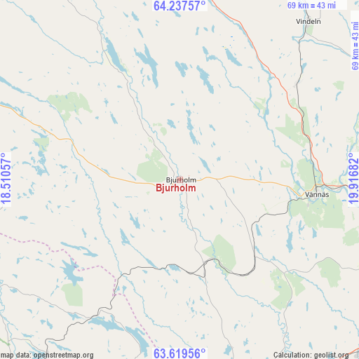
Bjurholm GPS coordinates[2]
63° 55' 48.972" North, 19° 12' 49.284" East
| Map corner | latitude | longitude |
|---|---|---|
| Upper-left | 64.23757°, | 18.51057° |
| Center: | 63.93027°, | 19.21369° |
| Lower-right: | 63.61956°, | 19.91682° |
| Map W x H: | 68.7×68.7 km | = 42.7×42.7mi |
| max Lat: | 67.85572° ⇑6.9% North |
| Bjurholm: | 63.93027° |
| min Lat: | ⇓93.1% South 55.34337° |
| min Long | Bjurholm | max Long |
| 11.1712° | 19.21369° | 24.13676° |
| W 93.2%⇐ | ⇒6.8% E |
Elevation
Elevation of Bjurholm is 173 m = 568 ft, and this is 90.4 m = 297 ft above average elevation for this country.
| Max E: |
663 m = 2175 ft | 13.9% |
| Bjurholm | 173 m 568 ft | |
| Avg. | 82.6 m = 271 ft | |
Min E: |
-1 m = -3 ft | 86.1% |
See also: Sweden elevation on elevation.city.
Geographical zone
Bjurholm is located in North temperate zone (between Tropic of Cancer and the Arctic Circle). Distance of this North polar circle is 292.8 km =181.9 mi to North.| Distance of | km | miles | from Bjurholm |
|---|---|---|---|
| North Pole | 2898.7 | 1801.2 | to North |
| Arctic Circle | 292.8 | 181.9 | to North |
| Tropic Cancer | 4502.5 | 2797.7 | to South |
| Equator | 7108.4 | 4417 | to South |


Nearby cities:
15 places around Bjurholm: (largest is in red/bold)
• Ersmark
54.2 km =33.7 mi,  95°
95°
• Hörnefors
48.3 km =30 mi,  135°
135°
• Innertavle
59.9 km =37.2 mi, 102°
• Lögdeå
43.3 km =26.9 mi,  168°
168°
• Nordmaling
42.7 km =26.5 mi,  160°
160°
• Ramsele
22.3 km =13.9 mi,  47°
47°
• Rundvik
45.4 km =28.2 mi, 166°
• Röbäck
49.6 km =30.8 mi,  105°
105°
• Sunnansjö
20 km =12.4 mi,  19°
19°
• Tallåsen
45.1 km =28 mi,  335°
335°
• Tomtebo
58.3 km =36.2 mi, 103°
• Umeå
52.4 km =32.6 mi, 102°
• Vindeln
38.9 km =24.2 mi,  39°
39°
• Vännäs
26.7 km =16.6 mi, 95°
• Vännäsby
29.9 km =18.6 mi,  93°
93°
Sources, notices
• [Note1] Compared only with cities in Sweden existing in our database
• [Src1] Map data: © OpenStreetMap contributors (CC-BY-SA)
• [Src2] Other city data from geonames.org with taken over terms of usage.
• [Src3] Geographical zone / Annual Mean Temperature by Robert A. Rohde @ Wikipedia
