Vallåkra geodata
Vallåkra (Skåne) is a populated place; located in Sweden in Europe/Stockholm (GMT+2) time zone. With population of 800 people, there are 966 cities with bigger population in this country. Compared to other cities in Sweden, 93.2% of cities are located further ↑North; 83.2% of cities are located further →East and 51.8% of cities have higher elevation than Vallåkra. Note1
Administrative division(s):
- Level 1: Skåne
- Level 2: Helsingborg
- Level 3: Kvistofta
- Level 4: Kvistofta socken


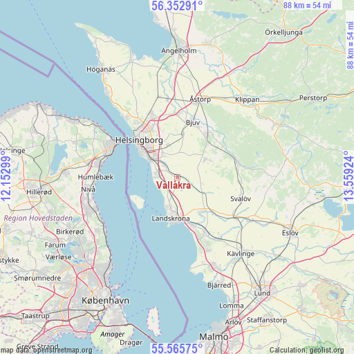
Vallåkra GPS coordinates[2]
55° 57' 40.788" North, 12° 51' 21.996" East
| Map corner | latitude | longitude |
|---|---|---|
| Upper-left | 56.35291°, | 12.15299° |
| Center: | 55.96133°, | 12.85611° |
| Lower-right: | 55.56575°, | 13.55924° |
| Map W x H: | 87.5×87.5 km | = 54.4×54.4mi |
| max Lat: | 67.85572° ⇑93.2% North |
| Vallåkra: | 55.96133° |
| min Lat: | ⇓6.8% South 55.34337° |
| min Long | Vallåkra | max Long |
| 11.1712° | 12.85611° | 24.13676° |
| W 16.8%⇐ | ⇒83.2% E |
Elevation
Elevation of Vallåkra is 47 m = 154 ft, and this is 35.6 m = 117 ft below average elevation for this country.
| Max E: |
663 m = 2175 ft | 51.8% |
| Avg. | 82.6 m = 271 ft | |
| Vallåkra | 47 m = 154 ft | |
Min E: |
-1 m = -3 ft | 48.2% |
See also: Sweden elevation on elevation.city.
Geographical zone
Vallåkra is located in North temperate zone (between Tropic of Cancer and the Arctic Circle). Distance of this North polar circle is 1178.9 km =732.5 mi to North.| Distance of | km | miles | from Vallåkra |
|---|---|---|---|
| North Pole | 3784.7 | 2351.7 | to North |
| Arctic Circle | 1178.9 | 732.5 | to North |
| Tropic Cancer | 3616.4 | 2247.1 | to South |
| Equator | 6222.3 | 3866.4 | to South |


Nearby cities:
15 places around Vallåkra: (largest is in red/bold)
• Asmundtorp
9.9 km =6.2 mi,  150°
150°
• Billeberga
12.5 km =7.8 mi,  134°
134°
• Billesholm
13.3 km =8.3 mi,  42°
42°
• Bjuv
14.2 km =8.8 mi,  16°
16°
• Bårslöv
6.2 km =3.9 mi,  329°
329°
• Ekeby
8.1 km =5 mi,  57°
57°
• Gantofta
4.3 km =2.7 mi,  312°
312°
• Glumslöv
3.7 km =2.3 mi,  232°
232°
• Helsingborg
13.8 km =8.6 mi, 313°
• Häljarp
12.9 km =8 mi,  163°
163°
• Kågeröd
15 km =9.3 mi,  73°
73°
• Landskrona
10.2 km =6.3 mi,  189°
189°
• Mörarp
10.8 km =6.7 mi,  7°
7°
• Påarp
8.4 km =5.2 mi,  342°
342°
• Rydebäck
5.6 km =3.5 mi,  276°
276°
Sources, notices
• [Note1] Compared only with cities in Sweden existing in our database
• [Src1] Map data: © OpenStreetMap contributors (CC-BY-SA)
• [Src2] Other city data from geonames.org with taken over terms of usage.
• [Src3] Geographical zone / Annual Mean Temperature by Robert A. Rohde @ Wikipedia
