Alingsås geodata
Alingsås (Västra Götaland) is a seat of a second-order administrative division; located in Sweden in Europe/Stockholm (GMT+2) time zone. With population of 26,329 people, there are 59 cities with bigger population in this country. Compared to other cities in Sweden, 61.8% of cities are located further ↑North; 88.1% of cities are located further →East and 58.6% of cities have lower elevation than Alingsås. Note1


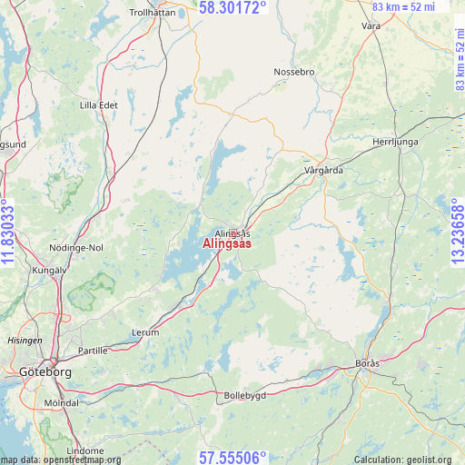
Alingsås GPS coordinates[2]
57° 55' 49.188" North, 12° 32' 0.42" East
| Map corner | latitude | longitude |
|---|---|---|
| Upper-left | 58.30172°, | 11.83033° |
| Center: | 57.93033°, | 12.53345° |
| Lower-right: | 57.55506°, | 13.23658° |
| Map W x H: | 83×83 km | = 51.6×51.6mi |
| max Lat: | 67.85572° ⇑61.8% North |
| Alingsås: | 57.93033° |
| min Lat: | ⇓38.2% South 55.34337° |
| min Long | Alingsås | max Long |
| 11.1712° | 12.53345° | 24.13676° |
| W 11.9%⇐ | ⇒88.1% E |
Elevation
Elevation of Alingsås is 66 m = 217 ft, and this is 16.6 m = 54 ft below average elevation for this country.
| Max E: |
663 m = 2175 ft | 41.4% |
| Avg. | 82.6 m = 271 ft | |
| Alingsås | 66 m = 217 ft | |
Min E: |
-1 m = -3 ft | 58.6% |
See also: Sweden elevation on elevation.city.
Geographical zone
Alingsås is located in North temperate zone (between Tropic of Cancer and the Arctic Circle). Distance of this North polar circle is 959.9 km =596.5 mi to North.| Distance of | km | miles | from Alingsås |
|---|---|---|---|
| North Pole | 3565.8 | 2215.7 | to North |
| Arctic Circle | 959.9 | 596.5 | to North |
| Tropic Cancer | 3835.3 | 2383.1 | to South |
| Equator | 6441.2 | 4002.4 | to South |


Nearby cities:
15 places around Alingsås: (largest is in red/bold)
• Björboholm
13.9 km =8.6 mi,  241°
241°
• Glommen
10.8 km =6.7 mi,  271°
271°
• Gråbo
17.3 km =10.7 mi,  232°
232°
• Ingared
9.2 km =5.7 mi,  211°
211°
• Jonstorp
13.3 km =8.3 mi,  54°
54°
• Lerum
23.7 km =14.7 mi,  221°
221°
• Olstorp
19.3 km =12 mi, 231°
• Sjövik
10 km =6.2 mi,  261°
261°
• Skepplanda
20.5 km =12.7 mi,  286°
286°
• Sollebrunn
20.7 km =12.9 mi,  359°
359°
• Stenkullen
19.8 km =12.3 mi, 220°
• Sålanda
19.6 km =12.2 mi, 287°
• Tollered
14.4 km =8.9 mi, 208°
• Vårgårda
20.1 km =12.5 mi, 53°
• Älvängen
24.4 km =15.2 mi,  277°
277°
Sources, notices
• [Note1] Compared only with cities in Sweden existing in our database
• [Src1] Map data: © OpenStreetMap contributors (CC-BY-SA)
• [Src2] Other city data from geonames.org with taken over terms of usage.
• [Src3] Geographical zone / Annual Mean Temperature by Robert A. Rohde @ Wikipedia
