Robertsfors geodata
Robertsfors (Västerbotten) is a seat of a second-order administrative division; located in Sweden in Europe/Stockholm (GMT+2) time zone. With population of 2,030 people, there are 517 cities with bigger population in this country. Compared to other cities in Sweden, 93.6% of cities are located further ↓South; 96.2% of cities are located further ←West and 56.2% of cities have lower elevation than Robertsfors. Note1


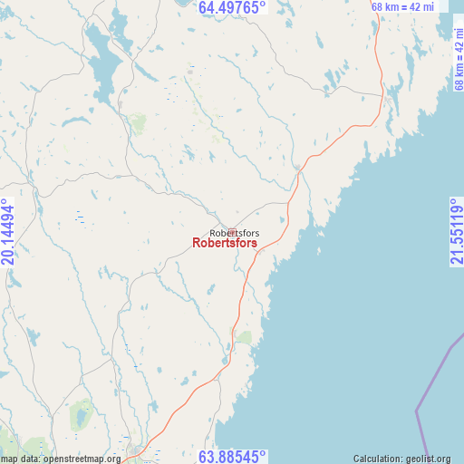
Robertsfors GPS coordinates[2]
64° 11' 35.664" North, 20° 50' 53.016" East
| Map corner | latitude | longitude |
|---|---|---|
| Upper-left | 64.49765°, | 20.14494° |
| Center: | 64.19324°, | 20.84806° |
| Lower-right: | 63.88545°, | 21.55119° |
| Map W x H: | 68.1×68.1 km | = 42.3×42.3mi |
| max Lat: | 67.85572° ⇑6.4% North |
| Robertsfors: | 64.19324° |
| min Lat: | ⇓93.6% South 55.34337° |
| min Long | Robertsfors | max Long |
| 11.1712° | 20.84806° | 24.13676° |
| W 96.2%⇐ | ⇒3.8% E |
Elevation
Elevation of Robertsfors is 62 m = 203 ft, and this is 20.6 m = 68 ft below average elevation for this country.
| Max E: |
663 m = 2175 ft | 43.8% |
| Avg. | 82.6 m = 271 ft | |
| Robertsfors | 62 m = 203 ft | |
Min E: |
-1 m = -3 ft | 56.2% |
See also: Sweden elevation on elevation.city.
Geographical zone
Robertsfors is located in North temperate zone (between Tropic of Cancer and the Arctic Circle). Distance of this North polar circle is 263.6 km =163.8 mi to North.| Distance of | km | miles | from Robertsfors |
|---|---|---|---|
| North Pole | 2869.4 | 1783 | to North |
| Arctic Circle | 263.6 | 163.8 | to North |
| Tropic Cancer | 4531.7 | 2815.9 | to South |
| Equator | 7137.6 | 4435.1 | to South |


Nearby cities:
15 places around Robertsfors: (largest is in red/bold)
• Bureå
50 km =31.1 mi,  19°
19°
• Burträsk
37.2 km =23.1 mi,  345°
345°
• Bygdeå
14.8 km =9.2 mi,  178°
178°
• Ersmark
43.1 km =26.8 mi,  216°
216°
• Innertavle
47.6 km =29.6 mi,  206°
206°
• Lövånger
29.1 km =18.1 mi,  48°
48°
• Röbäck
53.5 km =33.2 mi, 216°
• Skelleftehamn
57.5 km =35.7 mi, 18°
• Sävar
35.3 km =21.9 mi,  204°
204°
• Tomtebo
49.1 km =30.5 mi, 208°
• Täfteå
43.2 km =26.8 mi, 204°
• Umeå
49.7 km =30.9 mi, 215°
• Vindeln
54.6 km =33.9 mi,  270°
270°
• Vännäsby
58.6 km =36.4 mi,  238°
238°
• Ånäset
12.7 km =7.9 mi, 50°
Sources, notices
• [Note1] Compared only with cities in Sweden existing in our database
• [Src1] Map data: © OpenStreetMap contributors (CC-BY-SA)
• [Src2] Other city data from geonames.org with taken over terms of usage.
• [Src3] Geographical zone / Annual Mean Temperature by Robert A. Rohde @ Wikipedia
