Zgornje Jezersko geodata
Zgornje Jezersko (Jezersko) is a seat of a first-order administrative division; located in Slovenia in Europe/Ljubljana (GMT+2) time zone. With population of 568 people, there are 464 cities with bigger population in this country. Compared to other cities in Slovenia, 65.8% of cities are located further ↓South; 65.5% of cities are located further →East and 99.2% of cities have lower elevation than Zgornje Jezersko. Note1


Zgornje Jezersko GPS coordinates[2]
46° 23' 38.76" North, 14° 30' 23.724" East
| Map corner | latitude | longitude |
|---|---|---|
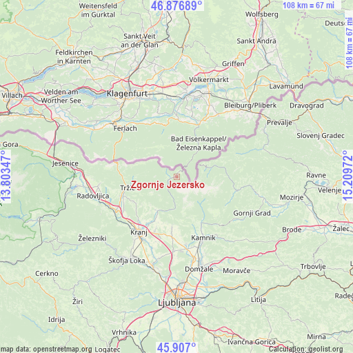
| Upper-left | 46.87689°, | 13.80347° |
| Center: | 46.3941°, | 14.50659° |
| Lower-right: | 45.907°, | 15.20972° |
| Map W x H: | 107.8×107.8 km | = 67×67mi |
| max Lat: | 46.83694° ⇑34.2% North |
| Zgornje Jezersko: | 46.3941° |
| min Lat: | ⇓65.8% South 45.47667° |
| min Long | Zgornje Jezersk | max Long |
| 13.52639° | 14.50659° | 16.4975° |
| W 34.5%⇐ | ⇒65.5% E |
Elevation
Elevation of Zgornje Jezersko is 985 m = 3232 ft, and this is 659.4 m = 2163 ft above average elevation for this country.
| Max E: |
1551 m = 5089 ft | 0.8% |
| Zgornje Jezersko | 985 m 3232 ft | |
| Avg. | 325.6 m = 1068 ft | |
Min E: |
2 m = 7 ft | 99.2% |
See also: Slovenia elevation on elevation.city.
Geographical zone
Zgornje Jezersko is located in North temperate zone (between Tropic of Cancer and the Arctic Circle). Distance of this North polar circle is 2242.6 km =1393.5 mi to North.| Distance of | km | miles | from Zgornje Jezersko |
|---|---|---|---|
| North Pole | 4848.5 | 3012.7 | to North |
| Arctic Circle | 2242.6 | 1393.5 | to North |
| Tropic Cancer | 2552.6 | 1586.1 | to South |
| Equator | 5158.5 | 3205.3 | to South |


Nearby cities:
15 places around Zgornje Jezersko: (largest is in red/bold)
• Bistrica pri Tržiču
17.1 km =10.6 mi,  255°
255°
• Britof
17.4 km =10.8 mi,  210°
210°
• Cerklje na Gorenjskem
15.6 km =9.7 mi,  185°
185°
• Godič
17.2 km =10.7 mi,  152°
152°
• Golnik
14.9 km =9.3 mi,  243°
243°
• Hotemaže
14.2 km =8.8 mi, 207°
• Križe
16.7 km =10.4 mi,  250°
250°
• Mlaka pri Kranju
17.2 km =10.7 mi,  224°
224°
• Preddvor
12 km =7.5 mi, 212°
• Predoslje
17 km =10.6 mi, 212°
• Pristava
16.6 km =10.3 mi, 252°
• Solčava
14.6 km =9.1 mi,  78°
78°
• Tržič
15.4 km =9.6 mi, 257°
• Visoko
15.3 km =9.5 mi, 206°
• Zgornji Brnik
17.3 km =10.7 mi, 185°
Sources, notices
• [Note1] Compared only with cities in Slovenia existing in our database
• [Src1] Map data: © OpenStreetMap contributors (CC-BY-SA)
• [Src2] Other city data from geonames.org with taken over terms of usage.
• [Src3] Geographical zone / Annual Mean Temperature by Robert A. Rohde @ Wikipedia
