Solčava geodata
Solčava is a seat of a first-order administrative division; located in Slovenia in Europe/Ljubljana (GMT+2) time zone. With population of 214 people, there are 591 cities with bigger population in this country. Compared to other cities in Slovenia, 70.5% of cities are located further ↓South; 57.2% of cities are located further →East and 96% of cities have lower elevation than Solčava. Note1


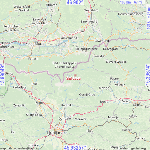
Solčava GPS coordinates[2]
46° 25' 9.984" North, 14° 41' 36.996" East
| Map corner | latitude | longitude |
|---|---|---|
| Upper-left | 46.902°, | 13.99049° |
| Center: | 46.41944°, | 14.69361° |
| Lower-right: | 45.93257°, | 15.39674° |
| Map W x H: | 107.8×107.8 km | = 67×67mi |
| max Lat: | 46.83694° ⇑29.5% North |
| Solčava: | 46.41944° |
| min Lat: | ⇓70.5% South 45.47667° |
| min Long | Solčava | max Long |
| 13.52639° | 14.69361° | 16.4975° |
| W 42.8%⇐ | ⇒57.2% E |
Elevation
Elevation of Solčava is 642 m = 2106 ft, and this is 316.4 m = 1038 ft above average elevation for this country.
| Max E: |
1551 m = 5089 ft | 4% |
| Solčava | 642 m 2106 ft | |
| Avg. | 325.6 m = 1068 ft | |
Min E: |
2 m = 7 ft | 96% |
See also: Slovenia elevation on elevation.city.
Geographical zone
Solčava is located in North temperate zone (between Tropic of Cancer and the Arctic Circle). Distance of this North polar circle is 2239.8 km =1391.7 mi to North.| Distance of | km | miles | from Solčava |
|---|---|---|---|
| North Pole | 4845.7 | 3011 | to North |
| Arctic Circle | 2239.8 | 1391.7 | to North |
| Tropic Cancer | 2555.4 | 1587.9 | to South |
| Equator | 5161.4 | 3207.1 | to South |


Nearby cities:
15 places around Solčava: (largest is in red/bold)
• Bočna
19 km =11.8 mi,  139°
139°
• Godič
19.2 km =11.9 mi,  199°
199°
• Gornji Grad
16.4 km =10.2 mi,  147°
147°
• Kamnik
22.4 km =13.9 mi, 196°
• Leše
19.5 km =12.1 mi,  51°
51°
• Ljubno ob Savinji
13.7 km =8.5 mi,  128°
128°
• Luče
8.1 km =5 mi, 149°
• Mekinje
21.5 km =13.4 mi, 195°
• Mežica
16.7 km =10.4 mi, 47°
• Nova Štifta
16.7 km =10.4 mi,  165°
165°
• Prevalje
22.4 km =13.9 mi, 50°
• Rečica ob Savinji
20.6 km =12.8 mi,  123°
123°
• Vrhpolje pri Kamniku
21.2 km =13.2 mi,  192°
192°
• Zgornje Jezersko
14.6 km =9.1 mi,  258°
258°
• Črna na Koroškem
13.3 km =8.3 mi,  64°
64°
Sources, notices
• [Note1] Compared only with cities in Slovenia existing in our database
• [Src1] Map data: © OpenStreetMap contributors (CC-BY-SA)
• [Src2] Other city data from geonames.org with taken over terms of usage.
• [Src3] Geographical zone / Annual Mean Temperature by Robert A. Rohde @ Wikipedia
