Vrhnika geodata
Vrhnika is a seat of a first-order administrative division; located in Slovenia in Europe/Ljubljana (GMT+2) time zone. With population of 8,413 people, there are 19 cities with bigger population in this country. Compared to other cities in Slovenia, 76.3% of cities are located further ↑North; 77.8% of cities are located further →East and 50.5% of cities have lower elevation than Vrhnika. Note1


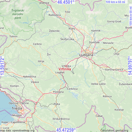
Vrhnika GPS coordinates[2]
45° 57' 48.6" North, 14° 17' 41.424" East
| Map corner | latitude | longitude |
|---|---|---|
| Upper-left | 46.4501°, | 13.59172° |
| Center: | 45.9635°, | 14.29484° |
| Lower-right: | 45.47259°, | 14.99797° |
| Map W x H: | 108.7×108.7 km | = 67.5×67.5mi |
| max Lat: | 46.83694° ⇑76.3% North |
| Vrhnika: | 45.9635° |
| min Lat: | ⇓23.7% South 45.47667° |
| min Long | Vrhnika | max Long |
| 13.52639° | 14.29484° | 16.4975° |
| W 22.2%⇐ | ⇒77.8% E |
Elevation
Elevation of Vrhnika is 297 m = 974 ft, and this is 28.6 m = 94 ft below average elevation for this country.
| Max E: |
1551 m = 5089 ft | 49.5% |
| Avg. | 325.6 m = 1068 ft | |
| Vrhnika | 297 m = 974 ft | |
Min E: |
2 m = 7 ft | 50.5% |
See also: Slovenia elevation on elevation.city.
Geographical zone
Vrhnika is located in North temperate zone (between Tropic of Cancer and the Arctic Circle). Distance of this North polar circle is 2290.5 km =1423.3 mi to North.| Distance of | km | miles | from Vrhnika |
|---|---|---|---|
| North Pole | 4896.4 | 3042.5 | to North |
| Arctic Circle | 2290.5 | 1423.3 | to North |
| Tropic Cancer | 2504.7 | 1556.3 | to South |
| Equator | 5110.7 | 3175.6 | to South |


Nearby cities:
15 places around Vrhnika: (largest is in red/bold)
• Bevke
5.2 km =3.2 mi,  64°
64°
• Borovnica
7.5 km =4.7 mi,  135°
135°
• Dragomer
9 km =5.6 mi,  49°
49°
• Drenov Grič
4.8 km =3 mi,  37°
37°
• Horjul
6.7 km =4.2 mi,  2°
2°
• Kamnik pod Krimom
8.8 km =5.5 mi,  102°
102°
• Log pri Brezovici
8.1 km =5 mi, 43°
• Logatec
7.6 km =4.7 mi,  224°
224°
• Notranje Gorice
8.5 km =5.3 mi,  71°
71°
• Podpeč
9.5 km =5.9 mi,  85°
85°
• Rovte
9.4 km =5.8 mi,  284°
284°
• Sinja Gorica
2.3 km =1.4 mi, 53°
• Stara Vrhnika
1.6 km =1 mi,  318°
318°
• Verd
1.1 km =0.7 mi,  131°
131°
• Vrzdenec
6.6 km =4.1 mi,  343°
343°
Sources, notices
• [Note1] Compared only with cities in Slovenia existing in our database
• [Src1] Map data: © OpenStreetMap contributors (CC-BY-SA)
• [Src2] Other city data from geonames.org with taken over terms of usage.
• [Src3] Geographical zone / Annual Mean Temperature by Robert A. Rohde @ Wikipedia
