Uršna Sela geodata
Uršna Sela (Novo Mesto) is a populated place; located in Slovenia in Europe/Ljubljana (GMT+2) time zone. With population of 626 people, there are 417 cities with bigger population in this country. Compared to other cities in Slovenia, 90.7% of cities are located further ↑North; 56.7% of cities are located further ←West and 60.2% of cities have lower elevation than Uršna Sela. Note1


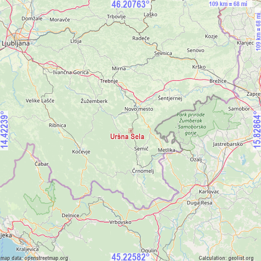
Uršna Sela GPS coordinates[2]
45° 43' 7.968" North, 15° 7' 31.836" East
| Map corner | latitude | longitude |
|---|---|---|
| Upper-left | 46.20763°, | 14.42239° |
| Center: | 45.71888°, | 15.12551° |
| Lower-right: | 45.22582°, | 15.82864° |
| Map W x H: | 109.2×109.2 km | = 67.9×67.9mi |
| max Lat: | 46.83694° ⇑90.7% North |
| Uršna Sela: | 45.71888° |
| min Lat: | ⇓9.3% South 45.47667° |
| min Long | Uršna Sela | max Long |
| 13.52639° | 15.12551° | 16.4975° |
| W 56.7%⇐ | ⇒43.3% E |
Elevation
Elevation of Uršna Sela is 328 m = 1076 ft, and this is 2.4 m = 8 ft above average elevation for this country.
| Max E: |
1551 m = 5089 ft | 39.8% |
| Uršna Sela | 328 m 1076 ft | |
| Avg. | 325.6 m = 1068 ft | |
Min E: |
2 m = 7 ft | 60.2% |
See also: Slovenia elevation on elevation.city.
Geographical zone
Uršna Sela is located in North temperate zone (between Tropic of Cancer and the Arctic Circle). Distance of this North polar circle is 2317.7 km =1440.2 mi to North.| Distance of | km | miles | from Uršna Sela |
|---|---|---|---|
| North Pole | 4923.6 | 3059.4 | to North |
| Arctic Circle | 2317.7 | 1440.2 | to North |
| Tropic Cancer | 2477.5 | 1539.4 | to South |
| Equator | 5083.5 | 3158.7 | to South |


Nearby cities:
15 places around Uršna Sela: (largest is in red/bold)
• Dolenjske Toplice
6.6 km =4.1 mi,  309°
309°
• Gabrje
13.6 km =8.5 mi,  58°
58°
• Kanižarica
19 km =11.8 mi,  170°
170°
• Lokve
13.6 km =8.5 mi,  163°
163°
• Metlika
16.7 km =10.4 mi,  118°
118°
• Mirna Peč
16.1 km =10 mi,  348°
348°
• Novo Mesto
10 km =6.2 mi,  19°
19°
• Otočec
15.5 km =9.6 mi,  29°
29°
• Semič
9.2 km =5.7 mi,  151°
151°
• Straža
7.9 km =4.9 mi,  328°
328°
• Velike Brusnice
14 km =8.7 mi,  47°
47°
• Črnomelj
17.2 km =10.7 mi, 163°
• Šmarješke Toplice
17.6 km =10.9 mi, 25°
• Željne
19.7 km =12.2 mi,  250°
250°
• Žužemberk
19.9 km =12.4 mi, 310°
Sources, notices
• [Note1] Compared only with cities in Slovenia existing in our database
• [Src1] Map data: © OpenStreetMap contributors (CC-BY-SA)
• [Src2] Other city data from geonames.org with taken over terms of usage.
• [Src3] Geographical zone / Annual Mean Temperature by Robert A. Rohde @ Wikipedia
