Črnomelj geodata
Črnomelj is a seat of a first-order administrative division; located in Slovenia in Europe/Ljubljana (GMT+2) time zone. With population of 5,776 people, there are 33 cities with bigger population in this country. Compared to other cities in Slovenia, 94.5% of cities are located further ↑North; 60.2% of cities are located further ←West and 91.5% of cities have higher elevation than Črnomelj. Note1


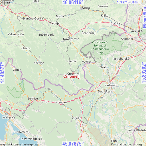
Črnomelj GPS coordinates[2]
45° 34' 15.996" North, 15° 11' 20.004" East
| Map corner | latitude | longitude |
|---|---|---|
| Upper-left | 46.06116°, | 14.48577° |
| Center: | 45.57111°, | 15.18889° |
| Lower-right: | 45.07675°, | 15.89202° |
| Map W x H: | 109.5×109.5 km | = 68×68mi |
| max Lat: | 46.83694° ⇑94.5% North |
| Črnomelj: | 45.57111° |
| min Lat: | ⇓5.5% South 45.47667° |
| min Long | Črnomelj | max Long |
| 13.52639° | 15.18889° | 16.4975° |
| W 60.2%⇐ | ⇒39.8% E |
Elevation
Elevation of Črnomelj is 150 m = 492 ft, and this is 175.6 m = 576 ft below average elevation for this country.
| Max E: |
1551 m = 5089 ft | 91.5% |
| Avg. | 325.6 m = 1068 ft | |
| Črnomelj | 150 m = 492 ft | |
Min E: |
2 m = 7 ft | 8.5% |
See also: Slovenia elevation on elevation.city.
Geographical zone
Črnomelj is located in North temperate zone (between Tropic of Cancer and the Arctic Circle). Distance of this North polar circle is 2334.1 km =1450.3 mi to North.| Distance of | km | miles | from Črnomelj |
|---|---|---|---|
| North Pole | 4940 | 3069.6 | to North |
| Arctic Circle | 2334.1 | 1450.3 | to North |
| Tropic Cancer | 2461.1 | 1529.3 | to South |
| Equator | 5067 | 3148.5 | to South |


Nearby cities:
15 places around Črnomelj: (largest is in red/bold)
• Dolenjske Toplice
23 km =14.3 mi,  333°
333°
• Dolga Vas
24.2 km =15 mi,  282°
282°
• Gabrje
24.4 km =15.2 mi,  15°
15°
• Kanižarica
2.9 km =1.8 mi,  216°
216°
• Kostel
22.8 km =14.2 mi,  252°
252°
• Kočevje
26.6 km =16.5 mi,  287°
287°
• Lokve
3.6 km =2.2 mi,  341°
341°
• Metlika
12.9 km =8 mi,  49°
49°
• Novo Mesto
25.9 km =16.1 mi,  356°
356°
• Semič
8.4 km =5.2 mi, 356°
• Straža
24.9 km =15.5 mi, 338°
• Uršna Sela
17.2 km =10.7 mi, 343°
• Velike Brusnice
26.4 km =16.4 mi,  11°
11°
• Šalka Vas
25.5 km =15.8 mi, 290°
• Željne
25.5 km =15.8 mi, 292°
Sources, notices
• [Note1] Compared only with cities in Slovenia existing in our database
• [Src1] Map data: © OpenStreetMap contributors (CC-BY-SA)
• [Src2] Other city data from geonames.org with taken over terms of usage.
• [Src3] Geographical zone / Annual Mean Temperature by Robert A. Rohde @ Wikipedia
