Rogatec geodata
Rogatec is a seat of a first-order administrative division; located in Slovenia in Europe/Ljubljana (GMT+2) time zone. With population of 1,558 people, there are 138 cities with bigger population in this country. Compared to other cities in Slovenia, 54.7% of cities are located further ↑North; 78.7% of cities are located further ←West and 70.2% of cities have higher elevation than Rogatec. Note1


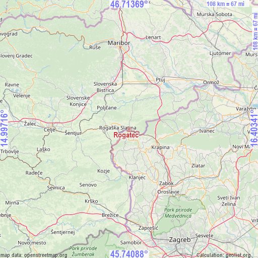
Rogatec GPS coordinates[2]
46° 13' 45.984" North, 15° 42' 1.008" East
| Map corner | latitude | longitude |
|---|---|---|
| Upper-left | 46.71369°, | 14.99716° |
| Center: | 46.22944°, | 15.70028° |
| Lower-right: | 45.74088°, | 16.40341° |
| Map W x H: | 108.2×108.2 km | = 67.2×67.2mi |
| max Lat: | 46.83694° ⇑54.7% North |
| Rogatec: | 46.22944° |
| min Lat: | ⇓45.3% South 45.47667° |
| min Long | Rogatec | max Long |
| 13.52639° | 15.70028° | 16.4975° |
| W 78.7%⇐ | ⇒21.3% E |
Elevation
Elevation of Rogatec is 241 m = 791 ft, and this is 84.6 m = 278 ft below average elevation for this country.
| Max E: |
1551 m = 5089 ft | 70.2% |
| Avg. | 325.6 m = 1068 ft | |
| Rogatec | 241 m = 791 ft | |
Min E: |
2 m = 7 ft | 29.8% |
See also: Slovenia elevation on elevation.city.
Geographical zone
Rogatec is located in North temperate zone (between Tropic of Cancer and the Arctic Circle). Distance of this North polar circle is 2260.9 km =1404.9 mi to North.| Distance of | km | miles | from Rogatec |
|---|---|---|---|
| North Pole | 4866.8 | 3024.1 | to North |
| Arctic Circle | 2260.9 | 1404.9 | to North |
| Tropic Cancer | 2534.3 | 1574.7 | to South |
| Equator | 5140.2 | 3194 | to South |


Nearby cities:
15 places around Rogatec: (largest is in red/bold)
• Apače
18.2 km =11.3 mi,  25°
25°
• Leskovec
17.9 km =11.1 mi,  343°
343°
• Lovrenc na Dravskem Polju
17.1 km =10.6 mi,  20°
20°
• Loče
17.3 km =10.7 mi,  296°
296°
• Majšperk
13.8 km =8.6 mi,  10°
10°
• Makole
10.1 km =6.3 mi,  345°
345°
• Podlehnik
18.1 km =11.2 mi,  49°
49°
• Podčetrtek
11.2 km =7 mi,  224°
224°
• Poljčane
13.1 km =8.1 mi,  314°
314°
• Rogaška Slatina
4.7 km =2.9 mi,  280°
280°
• Spodnje Poljčane
12.7 km =7.9 mi,  318°
318°
• Zgornje Poljčane
12.2 km =7.6 mi, 311°
• Črešnjevec
17.5 km =10.9 mi, 338°
• Šmarje pri Jelšah
13.9 km =8.6 mi,  268°
268°
• Žetale
10.9 km =6.8 mi,  63°
63°
Sources, notices
• [Note1] Compared only with cities in Slovenia existing in our database
• [Src1] Map data: © OpenStreetMap contributors (CC-BY-SA)
• [Src2] Other city data from geonames.org with taken over terms of usage.
• [Src3] Geographical zone / Annual Mean Temperature by Robert A. Rohde @ Wikipedia
