Rogaška Slatina geodata
Rogaška Slatina is a seat of a first-order administrative division; located in Slovenia in Europe/Ljubljana (GMT+2) time zone. With population of 5,111 people, there are 38 cities with bigger population in this country. Compared to other cities in Slovenia, 53.2% of cities are located further ↑North; 75% of cities are located further ←West and 71.7% of cities have higher elevation than Rogaška Slatina. Note1


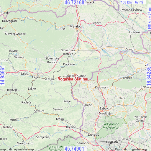
Rogaška Slatina GPS coordinates[2]
46° 14' 15" North, 15° 38' 22.992" East
| Map corner | latitude | longitude |
|---|---|---|
| Upper-left | 46.72168°, | 14.9366° |
| Center: | 46.2375°, | 15.63972° |
| Lower-right: | 45.74901°, | 16.34285° |
| Map W x H: | 108.2×108.1 km | = 67.2×67.2mi |
| max Lat: | 46.83694° ⇑53.2% North |
| Rogaška Slatina: | 46.2375° |
| min Lat: | ⇓46.8% South 45.47667° |
| min Long | Rogaška Slatin | max Long |
| 13.52639° | 15.63972° | 16.4975° |
| W 75%⇐ | ⇒25% E |
Elevation
Elevation of Rogaška Slatina is 237 m = 778 ft, and this is 88.6 m = 291 ft below average elevation for this country.
| Max E: |
1551 m = 5089 ft | 71.7% |
| Avg. | 325.6 m = 1068 ft | |
| Rogaška Slatina | 237 m = 778 ft | |
Min E: |
2 m = 7 ft | 28.3% |
See also: Slovenia elevation on elevation.city.
Geographical zone
Rogaška Slatina is located in North temperate zone (between Tropic of Cancer and the Arctic Circle). Distance of this North polar circle is 2260 km =1404.3 mi to North.| Distance of | km | miles | from Rogaška Slatina |
|---|---|---|---|
| North Pole | 4865.9 | 3023.5 | to North |
| Arctic Circle | 2260 | 1404.3 | to North |
| Tropic Cancer | 2535.2 | 1575.3 | to South |
| Equator | 5141.1 | 3194.5 | to South |


Nearby cities:
15 places around Rogaška Slatina: (largest is in red/bold)
• Draža Vas
16.1 km =10 mi,  311°
311°
• Gorica pri Slivnici
16.9 km =10.5 mi,  250°
250°
• Leskovec
16.2 km =10.1 mi,  358°
358°
• Loče
12.8 km =8 mi,  302°
302°
• Majšperk
14.6 km =9.1 mi,  29°
29°
• Makole
9.1 km =5.7 mi,  13°
13°
• Podčetrtek
9.5 km =5.9 mi,  199°
199°
• Poljčane
9.5 km =5.9 mi,  330°
330°
• Rogatec
4.7 km =2.9 mi,  100°
100°
• Spodnje Poljčane
9.4 km =5.8 mi,  335°
335°
• Zgornje Poljčane
8.5 km =5.3 mi, 328°
• Črešnjevec
15.5 km =9.6 mi,  353°
353°
• Šmarje pri Jelšah
9.3 km =5.8 mi,  262°
262°
• Žetale
14.9 km =9.3 mi,  74°
74°
• Žiče
15 km =9.3 mi, 305°
Sources, notices
• [Note1] Compared only with cities in Slovenia existing in our database
• [Src1] Map data: © OpenStreetMap contributors (CC-BY-SA)
• [Src2] Other city data from geonames.org with taken over terms of usage.
• [Src3] Geographical zone / Annual Mean Temperature by Robert A. Rohde @ Wikipedia
