Izlake geodata
Izlake (Zagorje ob Savi) is a populated place; located in Slovenia in Europe/Ljubljana (GMT+2) time zone. With population of 1,181 people, there are 184 cities with bigger population in this country. Compared to other cities in Slovenia, 63.5% of cities are located further ↑North; 51.7% of cities are located further →East and 56.3% of cities have lower elevation than Izlake. Note1


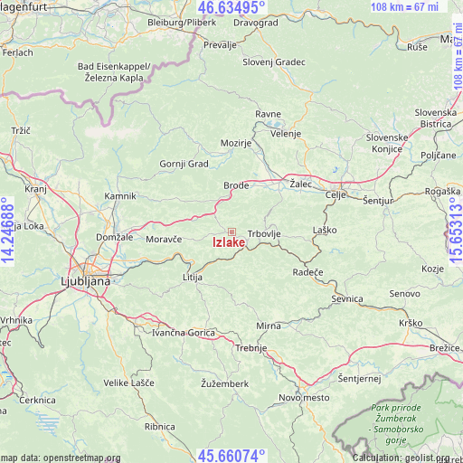
Izlake GPS coordinates[2]
46° 9' 0" North, 14° 57' 0" East
| Map corner | latitude | longitude |
|---|---|---|
| Upper-left | 46.63495°, | 14.24688° |
| Center: | 46.15°, | 14.95° |
| Lower-right: | 45.66074°, | 15.65313° |
| Map W x H: | 108.3×108.3 km | = 67.3×67.3mi |
| max Lat: | 46.83694° ⇑63.5% North |
| Izlake: | 46.15° |
| min Lat: | ⇓36.5% South 45.47667° |
| min Long | Izlake | max Long |
| 13.52639° | 14.95° | 16.4975° |
| W 48.3%⇐ | ⇒51.7% E |
Elevation
Elevation of Izlake is 315 m = 1033 ft, and this is 10.6 m = 35 ft below average elevation for this country.
| Max E: |
1551 m = 5089 ft | 43.7% |
| Avg. | 325.6 m = 1068 ft | |
| Izlake | 315 m = 1033 ft | |
Min E: |
2 m = 7 ft | 56.3% |
See also: Slovenia elevation on elevation.city.
Geographical zone
Izlake is located in North temperate zone (between Tropic of Cancer and the Arctic Circle). Distance of this North polar circle is 2269.8 km =1410.4 mi to North.| Distance of | km | miles | from Izlake |
|---|---|---|---|
| North Pole | 4875.7 | 3029.6 | to North |
| Arctic Circle | 2269.8 | 1410.4 | to North |
| Tropic Cancer | 2525.5 | 1569.3 | to South |
| Equator | 5131.4 | 3188.5 | to South |


Nearby cities:
15 places around Izlake: (largest is in red/bold)
• Dol pri Hrastniku
12.6 km =7.8 mi,  94°
94°
• Dolenja Vas
15.1 km =9.4 mi,  47°
47°
• Hrastnik
10.1 km =6.3 mi, 92°
• Kisovec
1.6 km =1 mi,  140°
140°
• Kresnice
13.7 km =8.5 mi,  247°
247°
• Latkova Vas
16 km =9.9 mi,  43°
43°
• Litija
14.1 km =8.8 mi,  224°
224°
• Moravče
15.9 km =9.9 mi,  264°
264°
• Pongrac
15.9 km =9.9 mi,  62°
62°
• Prebold
14.6 km =9.1 mi, 48°
• Tabor
10.9 km =6.8 mi,  28°
28°
• Trbovlje
8 km =5 mi, 86°
• Vransko
10.4 km =6.5 mi,  0°
0°
• Zagorje ob Savi
4.1 km =2.5 mi,  119°
119°
• Šmartno pri Litiji
14.3 km =8.9 mi,  214°
214°
Sources, notices
• [Note1] Compared only with cities in Slovenia existing in our database
• [Src1] Map data: © OpenStreetMap contributors (CC-BY-SA)
• [Src2] Other city data from geonames.org with taken over terms of usage.
• [Src3] Geographical zone / Annual Mean Temperature by Robert A. Rohde @ Wikipedia
