Hodoš geodata
Hodoš (Hodoš-Hodos) is a seat of a first-order administrative division; located in Slovenia in Europe/Ljubljana (GMT+2) time zone. With population of 228 people, there are 590 cities with bigger population in this country. Compared to other cities in Slovenia, 99.7% of cities are located further ↓South; 98.3% of cities are located further ←West and 73% of cities have higher elevation than Hodoš. Note1


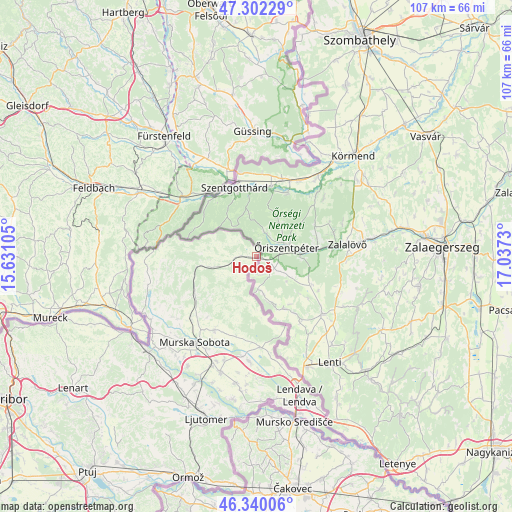
Hodoš GPS coordinates[2]
46° 49' 23.988" North, 16° 20' 3.012" East
| Map corner | latitude | longitude |
|---|---|---|
| Upper-left | 47.30229°, | 15.63105° |
| Center: | 46.82333°, | 16.33417° |
| Lower-right: | 46.34006°, | 17.0373° |
| Map W x H: | 107×107 km | = 66.5×66.5mi |
| max Lat: | 46.83694° ⇑0.3% North |
| Hodoš: | 46.82333° |
| min Lat: | ⇓99.7% South 45.47667° |
| min Long | Hodoš | max Long |
| 13.52639° | 16.33417° | 16.4975° |
| W 98.3%⇐ | ⇒1.7% E |
Elevation
Elevation of Hodoš is 234 m = 768 ft, and this is 91.6 m = 301 ft below average elevation for this country.
| Max E: |
1551 m = 5089 ft | 73% |
| Avg. | 325.6 m = 1068 ft | |
| Hodoš | 234 m = 768 ft | |
Min E: |
2 m = 7 ft | 27% |
See also: Slovenia elevation on elevation.city.
Geographical zone
Hodoš is located in North temperate zone (between Tropic of Cancer and the Arctic Circle). Distance of this North polar circle is 2194.9 km =1363.8 mi to North.| Distance of | km | miles | from Hodoš |
|---|---|---|---|
| North Pole | 4800.8 | 2983.1 | to North |
| Arctic Circle | 2194.9 | 1363.8 | to North |
| Tropic Cancer | 2600.3 | 1615.8 | to South |
| Equator | 5206.3 | 3235 | to South |


Nearby cities:
15 places around Hodoš: (largest is in red/bold)
• Bogojina
16.8 km =10.4 mi,  193°
193°
• Dobrovnik
19.2 km =11.9 mi,  175°
175°
• Gančani
22.1 km =13.7 mi,  196°
196°
• Gornji Petrovci
8.7 km =5.4 mi,  256°
256°
• Grad
18 km =11.2 mi, 261°
• Kobilje
16.2 km =10.1 mi,  162°
162°
• Kuzma
19.1 km =11.9 mi,  274°
274°
• Martjanci
18.4 km =11.4 mi,  214°
214°
• Moravske Toplice
17.8 km =11.1 mi, 208°
• Murska Sobota
22 km =13.7 mi,  215°
215°
• Puconci
18.8 km =11.7 mi,  226°
226°
• Rakičan
21.5 km =13.4 mi, 207°
• Renkovci
20.9 km =13 mi, 186°
• Turnišče
21.8 km =13.5 mi, 182°
• Šalovci
2.8 km =1.7 mi, 273°
Sources, notices
• [Note1] Compared only with cities in Slovenia existing in our database
• [Src1] Map data: © OpenStreetMap contributors (CC-BY-SA)
• [Src2] Other city data from geonames.org with taken over terms of usage.
• [Src3] Geographical zone / Annual Mean Temperature by Robert A. Rohde @ Wikipedia
