Rakičan geodata
Rakičan (Murska Sobota) is a populated place; located in Slovenia in Europe/Ljubljana (GMT+2) time zone. With population of 1,560 people, there are 137 cities with bigger population in this country. Compared to other cities in Slovenia, 95.3% of cities are located further ↓South; 94% of cities are located further ←West and 83.8% of cities have higher elevation than Rakičan. Note1


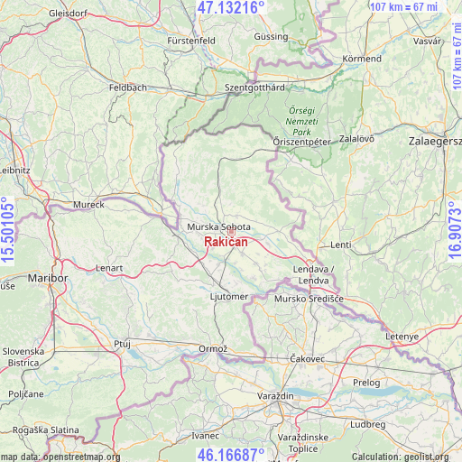
Rakičan GPS coordinates[2]
46° 39' 6.012" North, 16° 12' 15.012" East
| Map corner | latitude | longitude |
|---|---|---|
| Upper-left | 47.13216°, | 15.50105° |
| Center: | 46.65167°, | 16.20417° |
| Lower-right: | 46.16687°, | 16.9073° |
| Map W x H: | 107.3×107.3 km | = 66.7×66.7mi |
| max Lat: | 46.83694° ⇑4.7% North |
| Rakičan: | 46.65167° |
| min Lat: | ⇓95.3% South 45.47667° |
| min Long | Rakičan | max Long |
| 13.52639° | 16.20417° | 16.4975° |
| W 94%⇐ | ⇒6% E |
Elevation
Elevation of Rakičan is 185 m = 607 ft, and this is 140.6 m = 461 ft below average elevation for this country.
| Max E: |
1551 m = 5089 ft | 83.8% |
| Avg. | 325.6 m = 1068 ft | |
| Rakičan | 185 m = 607 ft | |
Min E: |
2 m = 7 ft | 16.2% |
See also: Slovenia elevation on elevation.city.
Geographical zone
Rakičan is located in North temperate zone (between Tropic of Cancer and the Arctic Circle). Distance of this North polar circle is 2214 km =1375.7 mi to North.| Distance of | km | miles | from Rakičan |
|---|---|---|---|
| North Pole | 4819.9 | 2994.9 | to North |
| Arctic Circle | 2214 | 1375.7 | to North |
| Tropic Cancer | 2581.3 | 1603.9 | to South |
| Equator | 5187.2 | 3223.2 | to South |


Nearby cities:
15 places around Rakičan: (largest is in red/bold)
• Bakovci
5.5 km =3.4 mi,  228°
228°
• Beltinci
5.9 km =3.7 mi,  151°
151°
• Bogojina
6.7 km =4.2 mi,  65°
65°
• Bratonci
3.9 km =2.4 mi,  162°
162°
• Dokležovje
5.7 km =3.5 mi,  200°
200°
• Gančani
4.2 km =2.6 mi,  120°
120°
• Ižakovci
7.1 km =4.4 mi,  169°
169°
• Krog
5 km =3.1 mi,  252°
252°
• Lipovci
3.2 km =2 mi,  144°
144°
• Martjanci
3.9 km =2.4 mi,  352°
352°
• Moravske Toplice
3.7 km =2.3 mi,  19°
19°
• Murska Sobota
3.1 km =1.9 mi,  292°
292°
• Puconci
7.1 km =4.4 mi,  329°
329°
• Pušča
5 km =3.1 mi,  275°
275°
• Černelavci
5.7 km =3.5 mi, 287°
Sources, notices
• [Note1] Compared only with cities in Slovenia existing in our database
• [Src1] Map data: © OpenStreetMap contributors (CC-BY-SA)
• [Src2] Other city data from geonames.org with taken over terms of usage.
• [Src3] Geographical zone / Annual Mean Temperature by Robert A. Rohde @ Wikipedia
