Bizeljsko geodata
Bizeljsko (Brežice) is a populated place; located in Slovenia in Europe/Ljubljana (GMT+2) time zone. With population of 691 people, there are 362 cities with bigger population in this country. Compared to other cities in Slovenia, 72.3% of cities are located further ↑North; 77.8% of cities are located further ←West and 87% of cities have higher elevation than Bizeljsko. Note1


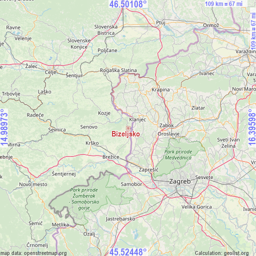
Bizeljsko GPS coordinates[2]
46° 0' 53.784" North, 15° 41' 34.26" East
| Map corner | latitude | longitude |
|---|---|---|
| Upper-left | 46.50108°, | 14.98973° |
| Center: | 46.01494°, | 15.69285° |
| Lower-right: | 45.52448°, | 16.39598° |
| Map W x H: | 108.6×108.6 km | = 67.5×67.5mi |
| max Lat: | 46.83694° ⇑72.3% North |
| Bizeljsko: | 46.01494° |
| min Lat: | ⇓27.7% South 45.47667° |
| min Long | Bizeljsko | max Long |
| 13.52639° | 15.69285° | 16.4975° |
| W 77.8%⇐ | ⇒22.2% E |
Elevation
Elevation of Bizeljsko is 174 m = 571 ft, and this is 151.6 m = 497 ft below average elevation for this country.
| Max E: |
1551 m = 5089 ft | 87% |
| Avg. | 325.6 m = 1068 ft | |
| Bizeljsko | 174 m = 571 ft | |
Min E: |
2 m = 7 ft | 13% |
See also: Slovenia elevation on elevation.city.
Geographical zone
Bizeljsko is located in North temperate zone (between Tropic of Cancer and the Arctic Circle). Distance of this North polar circle is 2284.8 km =1419.7 mi to North.| Distance of | km | miles | from Bizeljsko |
|---|---|---|---|
| North Pole | 4890.7 | 3038.9 | to North |
| Arctic Circle | 2284.8 | 1419.7 | to North |
| Tropic Cancer | 2510.5 | 1560 | to South |
| Equator | 5116.4 | 3179.2 | to South |


Nearby cities:
15 places around Bizeljsko: (largest is in red/bold)
• Bistrica ob Sotli
5.4 km =3.4 mi,  335°
335°
• Brestanica
16.8 km =10.4 mi,  262°
262°
• Brežice
14.7 km =9.1 mi,  212°
212°
• Dobje pri Planini
26.8 km =16.7 mi,  300°
300°
• Dobova
13.3 km =8.3 mi,  189°
189°
• Kozje
12.2 km =7.6 mi, 303°
• Krška Vas
16.1 km =10 mi,  217°
217°
• Krško
16.7 km =10.4 mi,  248°
248°
• Leskovec pri Krškem
19.2 km =11.9 mi,  242°
242°
• Podčetrtek
17.4 km =10.8 mi, 335°
• Rogatec
23.9 km =14.9 mi,  1°
1°
• Rogaška Slatina
25.1 km =15.6 mi,  350°
350°
• Sela pri Dobovi
11.9 km =7.4 mi,  202°
202°
• Senovo
16.7 km =10.4 mi,  273°
273°
• Šmarje pri Jelšah
27.1 km =16.8 mi,  330°
330°
Sources, notices
• [Note1] Compared only with cities in Slovenia existing in our database
• [Src1] Map data: © OpenStreetMap contributors (CC-BY-SA)
• [Src2] Other city data from geonames.org with taken over terms of usage.
• [Src3] Geographical zone / Annual Mean Temperature by Robert A. Rohde @ Wikipedia
