Podčetrtek geodata
Podčetrtek is a seat of a first-order administrative division; located in Slovenia in Europe/Ljubljana (GMT+2) time zone. With population of 528 people, there are 515 cities with bigger population in this country. Compared to other cities in Slovenia, 62% of cities are located further ↑North; 72.5% of cities are located further ←West and 76.2% of cities have higher elevation than Podčetrtek. Note1


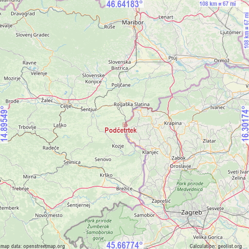
Podčetrtek GPS coordinates[2]
46° 9' 24.984" North, 15° 35' 54.996" East
| Map corner | latitude | longitude |
|---|---|---|
| Upper-left | 46.64183°, | 14.89549° |
| Center: | 46.15694°, | 15.59861° |
| Lower-right: | 45.66774°, | 16.30174° |
| Map W x H: | 108.3×108.3 km | = 67.3×67.3mi |
| max Lat: | 46.83694° ⇑62% North |
| Podčetrtek: | 46.15694° |
| min Lat: | ⇓38% South 45.47667° |
| min Long | Podčetrtek | max Long |
| 13.52639° | 15.59861° | 16.4975° |
| W 72.5%⇐ | ⇒27.5% E |
Elevation
Elevation of Podčetrtek is 220 m = 722 ft, and this is 105.6 m = 346 ft below average elevation for this country.
| Max E: |
1551 m = 5089 ft | 76.2% |
| Avg. | 325.6 m = 1068 ft | |
| Podčetrtek | 220 m = 722 ft | |
Min E: |
2 m = 7 ft | 23.8% |
See also: Slovenia elevation on elevation.city.
Geographical zone
Podčetrtek is located in North temperate zone (between Tropic of Cancer and the Arctic Circle). Distance of this North polar circle is 2269 km =1409.9 mi to North.| Distance of | km | miles | from Podčetrtek |
|---|---|---|---|
| North Pole | 4874.9 | 3029.1 | to North |
| Arctic Circle | 2269 | 1409.9 | to North |
| Tropic Cancer | 2526.3 | 1569.8 | to South |
| Equator | 5132.2 | 3189 | to South |


Nearby cities:
15 places around Podčetrtek: (largest is in red/bold)
• Bistrica ob Sotli
12 km =7.5 mi,  155°
155°
• Bizeljsko
17.4 km =10.8 mi, 155°
• Dobje pri Planini
15.9 km =9.9 mi,  262°
262°
• Gorica pri Slivnici
13.2 km =8.2 mi,  284°
284°
• Kozje
9.6 km =6 mi,  197°
197°
• Loče
17.6 km =10.9 mi,  334°
334°
• Makole
18.6 km =11.6 mi,  16°
16°
• Poljčane
17.3 km =10.7 mi,  355°
355°
• Rogatec
11.2 km =7 mi,  44°
44°
• Rogaška Slatina
9.5 km =5.9 mi, 19°
• Senovo
17.5 km =10.9 mi,  212°
212°
• Spodnje Poljčane
17.5 km =10.9 mi, 357°
• Zgornje Poljčane
16.2 km =10.1 mi, 355°
• Šentjur
16.9 km =10.5 mi,  293°
293°
• Šmarje pri Jelšah
9.9 km =6.2 mi,  321°
321°
Sources, notices
• [Note1] Compared only with cities in Slovenia existing in our database
• [Src1] Map data: © OpenStreetMap contributors (CC-BY-SA)
• [Src2] Other city data from geonames.org with taken over terms of usage.
• [Src3] Geographical zone / Annual Mean Temperature by Robert A. Rohde @ Wikipedia
