Apače geodata
Apače is a seat of a first-order administrative division; located in Slovenia in Europe/Ljubljana (GMT+2) time zone. With population of 528 people, there are 515 cities with bigger population in this country. Compared to other cities in Slovenia, 98.3% of cities are located further ↓South; 86.7% of cities are located further ←West and 76.7% of cities have higher elevation than Apače. Note1


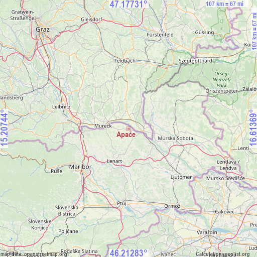
Apače GPS coordinates[2]
46° 41' 49.992" North, 15° 54' 38.016" East
| Map corner | latitude | longitude |
|---|---|---|
| Upper-left | 47.17731°, | 15.20744° |
| Center: | 46.69722°, | 15.91056° |
| Lower-right: | 46.21283°, | 16.61369° |
| Map W x H: | 107.2×107.2 km | = 66.6×66.6mi |
| max Lat: | 46.83694° ⇑1.7% North |
| Apače: | 46.69722° |
| min Lat: | ⇓98.3% South 45.47667° |
| min Long | Apače | max Long |
| 13.52639° | 15.91056° | 16.4975° |
| W 86.7%⇐ | ⇒13.3% E |
Elevation
Elevation of Apače is 218 m = 715 ft, and this is 107.6 m = 353 ft below average elevation for this country.
| Max E: |
1551 m = 5089 ft | 76.7% |
| Avg. | 325.6 m = 1068 ft | |
| Apače | 218 m = 715 ft | |
Min E: |
2 m = 7 ft | 23.3% |
See also: Slovenia elevation on elevation.city.
Geographical zone
Apače is located in North temperate zone (between Tropic of Cancer and the Arctic Circle). Distance of this North polar circle is 2208.9 km =1372.5 mi to North.| Distance of | km | miles | from Apače |
|---|---|---|---|
| North Pole | 4814.8 | 2991.8 | to North |
| Arctic Circle | 2208.9 | 1372.5 | to North |
| Tropic Cancer | 2586.3 | 1607.1 | to South |
| Equator | 5192.2 | 3226.3 | to South |


Nearby cities:
15 places around Apače: (largest is in red/bold)
• Benedikt
10 km =6.2 mi,  189°
189°
• Cankova
8.9 km =5.5 mi,  72°
72°
• Cerkvenjak
14.3 km =8.9 mi,  169°
169°
• Gornja Radgona
6.8 km =4.2 mi,  113°
113°
• Jurovski Dol
13.9 km =8.6 mi,  223°
223°
• Petanjci
12.8 km =8 mi, 112°
• Radenci
11.5 km =7.1 mi,  122°
122°
• Rogašovci
14.8 km =9.2 mi,  39°
39°
• Sladki Vrh
13.3 km =8.3 mi,  266°
266°
• Sv. Ana v Slov. Goricah
7.4 km =4.6 mi, 223°
• Sv. Trojica v Slov. Goricah
13.6 km =8.5 mi, 190°
• Tišina
14.5 km =9 mi, 107°
• Zgornja Velka
11.1 km =6.9 mi,  257°
257°
• Zgornja Ščavnica
6.9 km =4.3 mi,  229°
229°
• Črešnjevci
8 km =5 mi,  125°
125°
Sources, notices
• [Note1] Compared only with cities in Slovenia existing in our database
• [Src1] Map data: © OpenStreetMap contributors (CC-BY-SA)
• [Src2] Other city data from geonames.org with taken over terms of usage.
• [Src3] Geographical zone / Annual Mean Temperature by Robert A. Rohde @ Wikipedia
