Radenci geodata
Radenci is a seat of a first-order administrative division; located in Slovenia in Europe/Ljubljana (GMT+2) time zone. With population of 2,201 people, there are 89 cities with bigger population in this country. Compared to other cities in Slovenia, 94.8% of cities are located further ↓South; 90.2% of cities are located further ←West and 79.2% of cities have higher elevation than Radenci. Note1


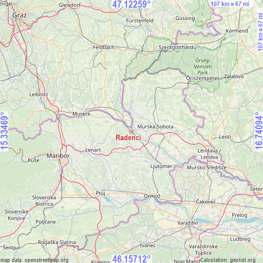
Radenci GPS coordinates[2]
46° 38' 31.236" North, 16° 2' 16.116" East
| Map corner | latitude | longitude |
|---|---|---|
| Upper-left | 47.12259°, | 15.33469° |
| Center: | 46.64201°, | 16.03781° |
| Lower-right: | 46.15712°, | 16.74094° |
| Map W x H: | 107.4×107.3 km | = 66.7×66.7mi |
| max Lat: | 46.83694° ⇑5.2% North |
| Radenci: | 46.64201° |
| min Lat: | ⇓94.8% South 45.47667° |
| min Long | Radenci | max Long |
| 13.52639° | 16.03781° | 16.4975° |
| W 90.2%⇐ | ⇒9.8% E |
Elevation
Elevation of Radenci is 205 m = 673 ft, and this is 120.6 m = 396 ft below average elevation for this country.
| Max E: |
1551 m = 5089 ft | 79.2% |
| Avg. | 325.6 m = 1068 ft | |
| Radenci | 205 m = 673 ft | |
Min E: |
2 m = 7 ft | 20.8% |
See also: Slovenia elevation on elevation.city.
Geographical zone
Radenci is located in North temperate zone (between Tropic of Cancer and the Arctic Circle). Distance of this North polar circle is 2215.1 km =1376.4 mi to North.| Distance of | km | miles | from Radenci |
|---|---|---|---|
| North Pole | 4821 | 2995.6 | to North |
| Arctic Circle | 2215.1 | 1376.4 | to North |
| Tropic Cancer | 2580.2 | 1603.3 | to South |
| Equator | 5186.1 | 3222.5 | to South |


Nearby cities:
15 places around Radenci: (largest is in red/bold)
• Bakovci
9 km =5.6 mi,  106°
106°
• Cankova
8.8 km =5.5 mi,  352°
352°
• Cerkvenjak
10.7 km =6.6 mi,  222°
222°
• Dokležovje
11.5 km =7.1 mi, 111°
• Gornja Radgona
4.9 km =3 mi,  315°
315°
• Križevci pri Ljutomeru
11.2 km =7 mi,  136°
136°
• Krog
7.9 km =4.9 mi,  93°
93°
• Murska Sobota
10.1 km =6.3 mi,  76°
76°
• Petanjci
2.5 km =1.6 mi,  59°
59°
• Pušča
7.9 km =4.9 mi, 78°
• Sveti Jurij ob Ščavnici
8.1 km =5 mi,  187°
187°
• Tišina
4.5 km =2.8 mi,  66°
66°
• Tropovci
5.2 km =3.2 mi, 75°
• Černelavci
7.8 km =4.8 mi, 69°
• Črešnjevci
3.5 km =2.2 mi,  293°
293°
Sources, notices
• [Note1] Compared only with cities in Slovenia existing in our database
• [Src1] Map data: © OpenStreetMap contributors (CC-BY-SA)
• [Src2] Other city data from geonames.org with taken over terms of usage.
• [Src3] Geographical zone / Annual Mean Temperature by Robert A. Rohde @ Wikipedia
