Tišina geodata
Tišina is a seat of a first-order administrative division; located in Slovenia in Europe/Ljubljana (GMT+2) time zone. With population of 404 people, there are 567 cities with bigger population in this country. Compared to other cities in Slovenia, 96.3% of cities are located further ↓South; 91.2% of cities are located further ←West and 81.5% of cities have higher elevation than Tišina. Note1


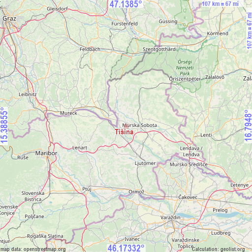
Tišina GPS coordinates[2]
46° 39' 29.016" North, 16° 5' 30.012" East
| Map corner | latitude | longitude |
|---|---|---|
| Upper-left | 47.1385°, | 15.38855° |
| Center: | 46.65806°, | 16.09167° |
| Lower-right: | 46.17332°, | 16.7948° |
| Map W x H: | 107.3×107.3 km | = 66.7×66.7mi |
| max Lat: | 46.83694° ⇑3.7% North |
| Tišina: | 46.65806° |
| min Lat: | ⇓96.3% South 45.47667° |
| min Long | Tišina | max Long |
| 13.52639° | 16.09167° | 16.4975° |
| W 91.2%⇐ | ⇒8.8% E |
Elevation
Elevation of Tišina is 192 m = 630 ft, and this is 133.6 m = 438 ft below average elevation for this country.
| Max E: |
1551 m = 5089 ft | 81.5% |
| Avg. | 325.6 m = 1068 ft | |
| Tišina | 192 m = 630 ft | |
Min E: |
2 m = 7 ft | 18.5% |
See also: Slovenia elevation on elevation.city.
Geographical zone
Tišina is located in North temperate zone (between Tropic of Cancer and the Arctic Circle). Distance of this North polar circle is 2213.3 km =1375.3 mi to North.| Distance of | km | miles | from Tišina |
|---|---|---|---|
| North Pole | 4819.2 | 2994.5 | to North |
| Arctic Circle | 2213.3 | 1375.3 | to North |
| Tropic Cancer | 2582 | 1604.4 | to South |
| Equator | 5187.9 | 3223.6 | to South |


Nearby cities:
15 places around Tišina: (largest is in red/bold)
• Bakovci
6.2 km =3.9 mi,  134°
134°
• Cankova
8.7 km =5.4 mi,  322°
322°
• Dokležovje
9 km =5.6 mi, 132°
• Gornja Radgona
7.8 km =4.8 mi,  282°
282°
• Krog
4.4 km =2.7 mi,  120°
120°
• Martjanci
8.7 km =5.4 mi,  68°
68°
• Murska Sobota
5.7 km =3.5 mi,  85°
85°
• Petanjci
2 km =1.2 mi,  254°
254°
• Puconci
7.3 km =4.5 mi,  42°
42°
• Pušča
3.6 km =2.2 mi, 94°
• Radenci
4.5 km =2.8 mi, 246°
• Rakičan
8.6 km =5.3 mi, 94°
• Tropovci
1 km =0.6 mi, 119°
• Černelavci
3.3 km =2.1 mi, 73°
• Črešnjevci
7.3 km =4.5 mi,  267°
267°
Sources, notices
• [Note1] Compared only with cities in Slovenia existing in our database
• [Src1] Map data: © OpenStreetMap contributors (CC-BY-SA)
• [Src2] Other city data from geonames.org with taken over terms of usage.
• [Src3] Geographical zone / Annual Mean Temperature by Robert A. Rohde @ Wikipedia
