Trstená geodata
Trstená (Žilinský kraj) is a populated place; located in Slovakia in Europe/Bratislava (GMT+2) time zone. With population of 7,461 people, there are 88 cities with bigger population in this country. Compared to other cities in Slovakia, 97.1% of cities are located further ↓South; 64.1% of cities are located further ←West and 87.1% of cities have lower elevation than Trstená. Note1


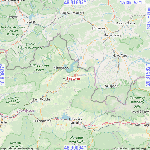
Trstená GPS coordinates[2]
49° 21' 39.636" North, 19° 36' 44.964" East
| Map corner | latitude | longitude |
|---|---|---|
| Upper-left | 49.81682°, | 18.90937° |
| Center: | 49.36101°, | 19.61249° |
| Lower-right: | 48.90094°, | 20.31562° |
| Map W x H: | 101.8×101.8 km | = 63.3×63.3mi |
| max Lat: | 49.43503° ⇑2.9% North |
| Trstená: | 49.36101° |
| min Lat: | ⇓97.1% South 47.76356° |
| min Long | Trstená | max Long |
| 16.9786° | 19.61249° | 22.18136° |
| W 64.1%⇐ | ⇒35.9% E |
Elevation
Elevation of Trstená is 607 m = 1991 ft, and this is 270.9 m = 889 ft above average elevation for this country.
| Max E: |
1006 m = 3301 ft | 12.9% |
| Trstená | 607 m 1991 ft | |
| Avg. | 336.1 m = 1103 ft | |
Min E: |
102 m = 335 ft | 87.1% |
See also: Slovakia elevation on elevation.city.
Geographical zone
Trstená is located in North temperate zone (between Tropic of Cancer and the Arctic Circle). Distance of this North polar circle is 1912.7 km =1188.5 mi to North.| Distance of | km | miles | from Trstená |
|---|---|---|---|
| North Pole | 4518.6 | 2807.7 | to North |
| Arctic Circle | 1912.7 | 1188.5 | to North |
| Tropic Cancer | 2882.5 | 1791.1 | to South |
| Equator | 5488.4 | 3410.3 | to South |


Nearby cities:
15 places around Trstená: (largest is in red/bold)
• Bešeňová
31.7 km =19.7 mi,  203°
203°
• Dolný Kubín
28 km =17.4 mi,  233°
233°
• Krušetnica
19.9 km =12.4 mi,  274°
274°
• Liptovská Sielnica
25.3 km =15.7 mi, 196°
• Liptovský Mikuláš
31.2 km =19.4 mi,  178°
178°
• Liptovský Trnovec
27.2 km =16.9 mi,  190°
190°
• Lúčky
29.9 km =18.6 mi,  210°
210°
• Nižná
8.5 km =5.3 mi, 228°
• Námestovo
10.9 km =6.8 mi,  298°
298°
• Oravská Lesná
31.3 km =19.4 mi, 271°
• Oravský Podzámok
21.7 km =13.5 mi,  238°
238°
• Pribylina
31.9 km =19.8 mi,  155°
155°
• Párnica
35.4 km =22 mi, 238°
• Svätý Kríž
35.1 km =21.8 mi, 189°
• Tvrdošín
4.9 km =3 mi, 236°
Sources, notices
• [Note1] Compared only with cities in Slovakia existing in our database
• [Src1] Map data: © OpenStreetMap contributors (CC-BY-SA)
• [Src2] Other city data from geonames.org with taken over terms of usage.
• [Src3] Geographical zone / Annual Mean Temperature by Robert A. Rohde @ Wikipedia
