Šurany geodata
Šurany (Nitriansky kraj) is a populated place; located in Slovakia in Europe/Bratislava (GMT+2) time zone. With population of 10,491 people, there are 66 cities with bigger population in this country. Compared to other cities in Slovakia, 91.8% of cities are located further ↑North; 72.9% of cities are located further →East and 91.2% of cities have higher elevation than Šurany. Note1


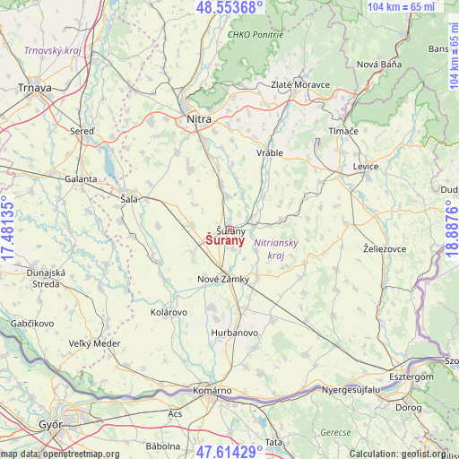
Šurany GPS coordinates[2]
48° 5' 10.068" North, 18° 11' 4.092" East
| Map corner | latitude | longitude |
|---|---|---|
| Upper-left | 48.55368°, | 17.48135° |
| Center: | 48.08613°, | 18.18447° |
| Lower-right: | 47.61429°, | 18.8876° |
| Map W x H: | 104.5×104.4 km | = 64.9×64.9mi |
| max Lat: | 49.43503° ⇑91.8% North |
| Šurany: | 48.08613° |
| min Lat: | ⇓8.2% South 47.76356° |
| min Long | Šurany | max Long |
| 16.9786° | 18.18447° | 22.18136° |
| W 27.1%⇐ | ⇒72.9% E |
Elevation
Elevation of Šurany is 122 m = 400 ft, and this is 214.1 m = 702 ft below average elevation for this country.
| Max E: |
1006 m = 3301 ft | 91.2% |
| Avg. | 336.1 m = 1103 ft | |
| Šurany | 122 m = 400 ft | |
Min E: |
102 m = 335 ft | 8.8% |
See also: Slovakia elevation on elevation.city.
Geographical zone
Šurany is located in North temperate zone (between Tropic of Cancer and the Arctic Circle). Distance of this North polar circle is 2054.5 km =1276.6 mi to North.| Distance of | km | miles | from Šurany |
|---|---|---|---|
| North Pole | 4660.4 | 2895.8 | to North |
| Arctic Circle | 2054.5 | 1276.6 | to North |
| Tropic Cancer | 2740.8 | 1703.1 | to South |
| Equator | 5346.7 | 3322.3 | to South |


Nearby cities:
15 places around Šurany: (largest is in red/bold)
• Galanta
35.8 km =22.2 mi,  288°
288°
• Hurbanovo
24.1 km =15 mi,  178°
178°
• Kolárovo
23.5 km =14.6 mi,  219°
219°
• Komárno
10.4 km =6.5 mi,  70°
70°
• Komárno
36.2 km =22.5 mi,  187°
187°
• Levice
34.5 km =21.4 mi, 65°
• Nitra
25.7 km =16 mi,  343°
343°
• Nové Zámky
11.3 km =7 mi, 188°
• Svodín
30.5 km =19 mi,  129°
129°
• Tlmače
34.2 km =21.3 mi,  48°
48°
• Vráble
19.8 km =12.3 mi,  27°
27°
• Vágfüzes
27.9 km =17.3 mi,  200°
200°
• Zlaté Moravce
36.9 km =22.9 mi, 25°
• Šaľa
23.7 km =14.7 mi, 287°
• Želiezovce
35.1 km =21.8 mi,  96°
96°
Sources, notices
• [Note1] Compared only with cities in Slovakia existing in our database
• [Src1] Map data: © OpenStreetMap contributors (CC-BY-SA)
• [Src2] Other city data from geonames.org with taken over terms of usage.
• [Src3] Geographical zone / Annual Mean Temperature by Robert A. Rohde @ Wikipedia
