Šaľa geodata
Šaľa (Nitriansky kraj) is a seat of a second-order administrative division; located in Slovakia in Europe/Bratislava (GMT+2) time zone. With population of 24,513 people, there are 27 cities with bigger population in this country. Compared to other cities in Slovakia, 90% of cities are located further ↑North; 80% of cities are located further →East and 95.3% of cities have higher elevation than Šaľa. Note1


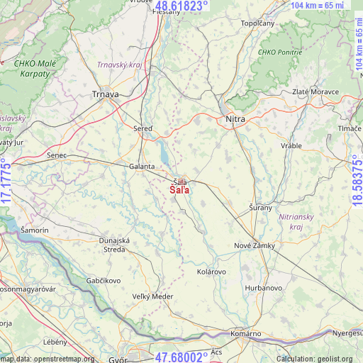
Šaľa GPS coordinates[2]
48° 9' 4.572" North, 17° 52' 50.232" East
| Map corner | latitude | longitude |
|---|---|---|
| Upper-left | 48.61823°, | 17.1775° |
| Center: | 48.15127°, | 17.88062° |
| Lower-right: | 47.68002°, | 18.58375° |
| Map W x H: | 104.3×104.3 km | = 64.8×64.8mi |
| max Lat: | 49.43503° ⇑90% North |
| Šaľa: | 48.15127° |
| min Lat: | ⇓10% South 47.76356° |
| min Long | Šaľa | max Long |
| 16.9786° | 17.88062° | 22.18136° |
| W 20%⇐ | ⇒80% E |
Elevation
Elevation of Šaľa is 114 m = 374 ft, and this is 222.1 m = 729 ft below average elevation for this country.
| Max E: |
1006 m = 3301 ft | 95.3% |
| Avg. | 336.1 m = 1103 ft | |
| Šaľa | 114 m = 374 ft | |
Min E: |
102 m = 335 ft | 4.7% |
See also: Slovakia elevation on elevation.city.
Geographical zone
Šaľa is located in North temperate zone (between Tropic of Cancer and the Arctic Circle). Distance of this North polar circle is 2047.3 km =1272.1 mi to North.| Distance of | km | miles | from Šaľa |
|---|---|---|---|
| North Pole | 4653.1 | 2891.3 | to North |
| Arctic Circle | 2047.3 | 1272.1 | to North |
| Tropic Cancer | 2748 | 1707.5 | to South |
| Equator | 5353.9 | 3326.8 | to South |


Nearby cities:
15 places around Šaľa: (largest is in red/bold)
• Dunajská Streda
26.6 km =16.5 mi,  228°
228°
• Galanta
12.1 km =7.5 mi,  290°
290°
• Hlohovec
31.7 km =19.7 mi,  349°
349°
• Kolárovo
26.5 km =16.5 mi,  163°
163°
• Komárno
32.6 km =20.3 mi,  96°
96°
• Leopoldov
33.8 km =21 mi, 345°
• Nitra
23 km =14.3 mi,  40°
40°
• Nové Zámky
27.9 km =17.3 mi,  131°
131°
• Senec
36.4 km =22.6 mi,  282°
282°
• Sládkovičovo
18.8 km =11.7 mi, 287°
• Trnava
33.2 km =20.6 mi,  319°
319°
• Veľký Meder
33.7 km =20.9 mi,  194°
194°
• Vráble
33.3 km =20.7 mi,  72°
72°
• Vágfüzes
35.7 km =22.2 mi, 159°
• Šurany
23.7 km =14.7 mi,  107°
107°
Sources, notices
• [Note1] Compared only with cities in Slovakia existing in our database
• [Src1] Map data: © OpenStreetMap contributors (CC-BY-SA)
• [Src2] Other city data from geonames.org with taken over terms of usage.
• [Src3] Geographical zone / Annual Mean Temperature by Robert A. Rohde @ Wikipedia
