Levice geodata
Levice (Nitriansky kraj) is a seat of a second-order administrative division; located in Slovakia in Europe/Bratislava (GMT+2) time zone. With population of 37,574 people, there are 16 cities with bigger population in this country. Compared to other cities in Slovakia, 85.3% of cities are located further ↑North; 63.5% of cities are located further →East and 76.5% of cities have higher elevation than Levice. Note1


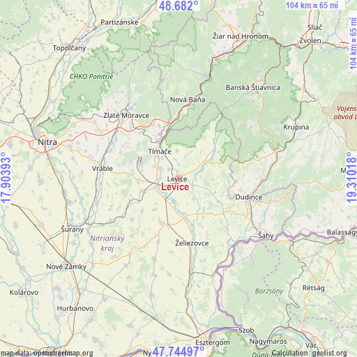
Levice GPS coordinates[2]
48° 12' 56.268" North, 18° 36' 25.38" East
| Map corner | latitude | longitude |
|---|---|---|
| Upper-left | 48.682°, | 17.90393° |
| Center: | 48.21563°, | 18.60705° |
| Lower-right: | 47.74497°, | 19.31018° |
| Map W x H: | 104.2×104.2 km | = 64.7×64.7mi |
| max Lat: | 49.43503° ⇑85.3% North |
| Levice: | 48.21563° |
| min Lat: | ⇓14.7% South 47.76356° |
| min Long | Levice | max Long |
| 16.9786° | 18.60705° | 22.18136° |
| W 36.5%⇐ | ⇒63.5% E |
Elevation
Elevation of Levice is 162 m = 531 ft, and this is 174.1 m = 571 ft below average elevation for this country.
| Max E: |
1006 m = 3301 ft | 76.5% |
| Avg. | 336.1 m = 1103 ft | |
| Levice | 162 m = 531 ft | |
Min E: |
102 m = 335 ft | 23.5% |
See also: Slovakia elevation on elevation.city.
Geographical zone
Levice is located in North temperate zone (between Tropic of Cancer and the Arctic Circle). Distance of this North polar circle is 2040.1 km =1267.7 mi to North.| Distance of | km | miles | from Levice |
|---|---|---|---|
| North Pole | 4646 | 2886.9 | to North |
| Arctic Circle | 2040.1 | 1267.7 | to North |
| Tropic Cancer | 2755.2 | 1712 | to South |
| Equator | 5361.1 | 3331.2 | to South |


Nearby cities:
15 places around Levice: (largest is in red/bold)
• Banská Štiavnica
34.2 km =21.3 mi,  40°
40°
• Dudince
21.4 km =13.3 mi,  103°
103°
• Komárno
24.2 km =15 mi,  242°
242°
• Krupina
37.3 km =23.2 mi,  65°
65°
• Nová Baňa
23.2 km =14.4 mi,  6°
6°
• Svodín
34.8 km =21.6 mi,  193°
193°
• Svätý Anton
33.5 km =20.8 mi,  47°
47°
• Tlmače
9.9 km =6.2 mi,  325°
325°
• Voznica
28.1 km =17.5 mi, 14°
• Vráble
22.3 km =13.9 mi,  278°
278°
• Zlaté Moravce
24.3 km =15.1 mi,  321°
321°
• Šahy
29.9 km =18.6 mi,  121°
121°
• Šurany
34.5 km =21.4 mi,  245°
245°
• Žarnovica
30.6 km =19 mi,  15°
15°
• Želiezovce
18.7 km =11.6 mi,  169°
169°
Sources, notices
• [Note1] Compared only with cities in Slovakia existing in our database
• [Src1] Map data: © OpenStreetMap contributors (CC-BY-SA)
• [Src2] Other city data from geonames.org with taken over terms of usage.
• [Src3] Geographical zone / Annual Mean Temperature by Robert A. Rohde @ Wikipedia
